13 Sep , 2014
“Poor Kashmir, it lies in the Himalayan ramparts where the borders of India, Pakistan and China rub together. Reality mocks its beauty. There is no escaping the permeating meloncholy of a land that lies under the gun.” — Trevor Fishlock
Kashmir’s ‘locational’ relevance for India, China and Pakistan has always been significant and it has become a driver in its own right for the perpetual state of conflict with Pakistan and a reality which has the potential for keeping the Sino-Indian relations adversarial.
The indelible factors of geography in terms of ‘location,’ ‘space’ and ‘terrain’ in shaping the destiny of nations remains profound. The conflict that has been going on ‘for’ and ‘in’ the state of Jammu and Kashmir (J&K) for seven decades is a prime example; it is the State’s locational position on the face of the earth for China, India and Pakistan that is driving the triangular competition in which Pakistan’s virulence is being used both as the means to ‘contain’ India, and her territory, including what she occupies to act as a spring board for China’s regional outreach.
Contributing to the factors of geography are vestiges of the past. Shadows of history fall long and keep festering if the end state is allowed to remain open ended and if actions are not grounded in strategic logic. Such has been the case of Kashmir – both in handling Pakistan and China and failing to integrate the Kashmiri people. In the absence of the national will to correct what the Chinese call as ‘historic mistakes,’ outrages in the form of periodic sabre rattling and violence would continue – Keran and Samba are merely the recent of the many examples. While mistakes of the past cannot be undone and war is never a good option, corrective measures within a well calibrated operating matrix are always possible.
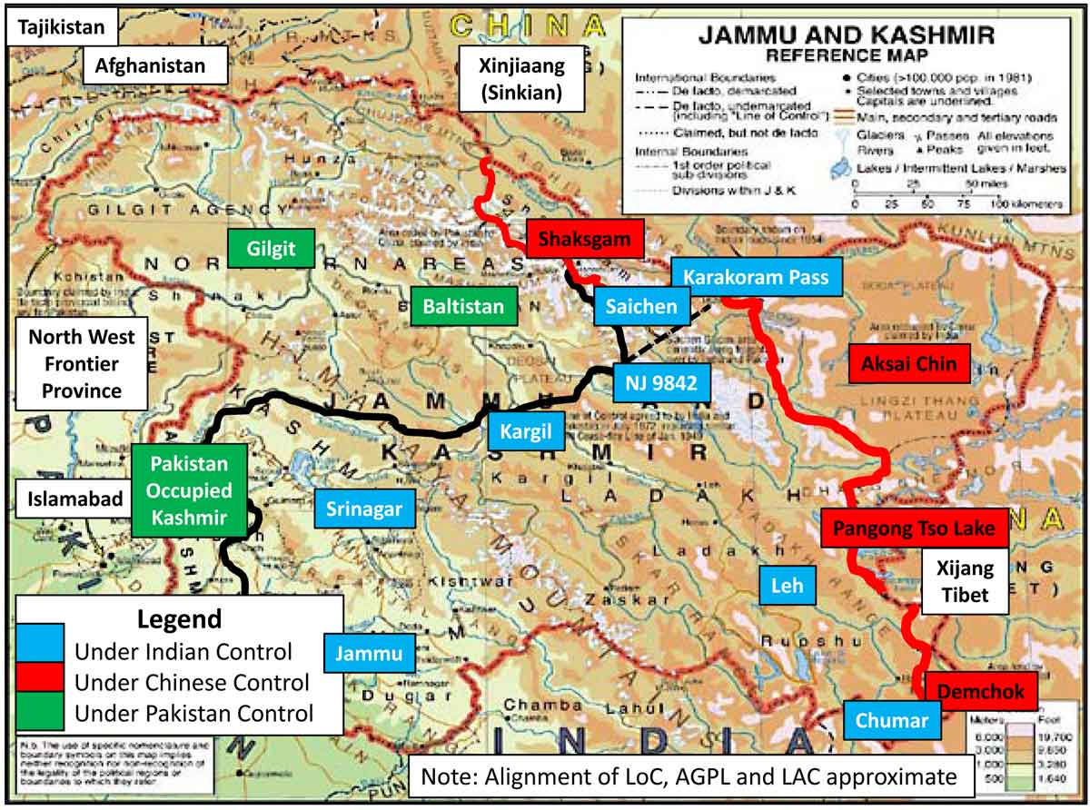
Though stating the obvious, it is important to highlight that the map is intended to draw attention to the adverse balance sheet after seven decades of conflict; out of the 2,22,236 square kms that originally comprised the Princely State of J & K, 56 percent has already passed under the control of China and Pakistan. The mutilated state of J&K is marked in black and red respectively-lines that have been drawn with blood of soldiers who continue their unending vigil in the absence of a coherent national strategy. At the same time the map reiterates Kashmir’s geographical proximity with Afghanistan, with which it shares a land border, and the proximity of the energy rich Central Asian Republics. Kashmir’s ‘locational’ relevance for India, China and Pakistan has always been significant and it has become a driver in its own right for the perpetual state of conflict with Pakistan and a reality which has the potential for keeping the Sino-Indian relations adversarial.
The triangular strategic competition between China and Pakistan on one side and India on the other is remicent of the Great Game of yesteryears; the aims and ends may have changed, but Kashmir’s strategic value as an avenue for Great Powers, remains a significant factor for conflict. China wants to develop her Silk Route through her territory (Gilgit-Baltistan) and India (ideally) would like to develop energy routes to the CAR nations through Afghanistan, which are best accessed through her territory/Pakistan. Since the aims are not complementary and there is no reason to expect a diplomatic solution, the ‘K’ factor and the dynamics it generates would add to the volatility and exacerbate the competition. If the frequency and scale of incidents of the current year are any indication, preliminary moves for setting the stage to exploit the post 2014 situation are already underway.
Compounding the situation is the issue of river waters since Kashmir is either the source or conduit of the rivers for both India and Pakistan, the war for control of water resources will exacerbate tensions.
The aim is to revisit the geo-strategic realities of J&K and argue the point that despite the desire to further the Indo-Pak peace process, unless there is a fundamental shift in Pakistan’s stance wrt Kashmir, there ‘cannot’ and ‘should not’ be any half baked solution. Given Kashmir’s emotive resonance and charged atmospherics, there is little that discussions and platitudes can accomplish. The reality that stares India in the face is that China’s rise is resulting in her outreach to the Arabian Sea and this requires her to consolidate in Gilgit Baltistan. At the same time, India’s future cannot be held hostage to a toxic and tottering Pakistan. How the situation may play out in geo-strategic terms remains uncertain, but what is certain is the fact that conflict which has been a constant for the region would continue, though its nature and tenor may undergo a change. How, where and in what shape Pakistan will feature and what would be China’s role in pursuing her regional goals will decide the outcome. At the same time, India cannot condense to pledge her future in what portends to be an uncertain environment.
Harsh that it might sound, but the bane for Kashmir and her people ‘is’ and ‘has’ been her strategic relevance and behind the protracted Indo-Pak conflict, obfuscrated under layers of misleading narratives, the core reason is ‘territorial’ –religion is merely the currency and the cover for the conflict. On the other hand, with China there is no need to obfuscate the raison-de-etre for the conflict – it is squarely Kashmir’s locational value as an access point and as an avenue. It was Kashmir’s pivotal location that was the reason for generating conflict for the state during the Great Game played between Czarist Russia and Imperial Britain. The only change that has come with the passage of time is that the actors have changed to India on one side and China and Pakistan on the other.
What has not changed is the fact that Kashmir which provided the avenue for ingress into the plains of the sub-continent remains as important, perhaps even greater since China is planning to develop her Silk Routes to the Arabian Sea coast and to West Asia and to the Middle East. There is no mitigating the fact that Afghanistan that has remained at the cusp of conflict remains fragile, and at the same time her locational relevance and economic importance has gone up exponentially in the latest version of the game. Compounding the situation is the issue of river waters since Kashmir is either the source or conduit of the rivers for both India and Pakistan, the war for control of water resources will exacerbate tensions.
Syed Salahuddin stated: “Kashmir is the source from where all of Pakistan’s water resources originate. If Pakistan loses its battle with India, it will become a desert.”.
Field Marshal Ayub Khan was candid in stating Pakistan’s compulsions to attempt to capture the state:“The very fact that Pakistan had to be content with the waters of the three western rivers (in accordance with the Indus water Treaty) underlined the importance for us of having physical control over the upper reaches for their maximum utilisation for the growing needs of Pakistan.”Syed Salahuddin, the Chairman of the United Jihad Council, the umbrella organisation cording the Pakistan sponsored Jihad in J & K graphically stated: “Kashmir is the source from where all of Pakistan’s water resources originate. If Pakistan loses its battle with India, it will become a desert.”In view of the foregoing, Kashmir and the immediate region would remain a hotspot and for India, remaining on the back-foot as a policy would be counterproductive in geo-strategic terms and grievously retard her potential.
Strategic backdrop. The Cease Fire Line delineated at the Karachi Agreement of 27 Jul 1949, accepted the de facto splitting of the state. On one hand, the creation of POK provided Pakistan a viable buffer against possible Indian aggression opposite her heartland, which translated to a great military advantage. By occupying Gilgit-Baltistan, Pakistan gained another significant strategic advantage, whose importance has grown with time. Pakistan’s control over this strategic region has opened up multi-dimensional spheres for cooperation/collusion with China. At the same time, the occupation of Aksai Chin and the territorial belt running to the southern tip of the Indo-Tibetan border in East Ladakh has not only put India in a perpetual defensive, but the loss of strategic passes in 1962 (Chang La, Jara La, Charding La and the like) restrict her options and place India at a disadvantage.
 When seen holistically, there can be no denial that these developments restrict India’s strategic options whose effect is expected to increase, as the situation gets adversarial. Since Pakistan is increasingly being seen by China as a means and end to further her regional strategic objectives, especially against India, this exacerbates the competition and portends further conflict for Kashmir as the state is physically the geo-strategic fulcrum for Sino-Pak collusion against India. In view of this growing reality, India’s strategic future in Kashmir needs a re-appraisal. Some geo-strategic issues that merit attention are postulated.
Should the Saichen Sector even be discussed?
The Siachen Sector is enclosed by the Soltoro Ridge in the west and the Karakoram Range in the north and east, while the Indo-Pak faceoff is over domination of the Soltoro Ridge, which India holds. At the same time, it is pertinent to mention that the sector has even more difficult borders with China, which are unmanned. The Indian sector enclosed by the Karakorams and the Soltoro Ranges, is the only piece of real estate over which India has operational control, and by virtue of its shape and location, this acts as a strategic wedge between Pak and China as can be seen on the map. Since both of India’s protagonists have converging interests in the region, the importance of this narrow wedge, juxtaposition between them remains invaluable for India.
Since both of India’s protagonists have converging interests in the region, the importance of this narrow wedge, juxtaposition between them remains invaluable for India.
It also needs to be reiterated that the triangular standoff that exists in the sector, is only one component of the larger India–Pak-China conflict and therefore cannot be seen in isolation. Chinese military presence in Gilgit-Baltistan, adds to the volatility and raises the importance of India’s hold over this strategically invaluable ‘frozen waste land.’ It is also pertinent to highlight that the Shyok River Axis connects Aksai Chin to Gilgit and therefore offers a shorter, easier and direct route between Chinese held Aksai Chin and Pak held Baltistan. This therefore offers a lucrative objective with strategic overtones in the Sino-Pak collusive games that can be played out against India in the future.
Thus while it is reiterated that there is no strategic mandate for a discussion on the subject, there are three basic questions which need to be answered before any decision can be considered by India. First, ‘can demilitarisation be verifiable and accountability apportioned? Second, does demilitarisation mean that Pakistan accepts the Indian interpretation of the LC/AGPL running along the watershed of Soltoro till the Karakorams. Third, will the potential safeguards guarantee that China, who already controls the Shaksgam Valley and occupies Aksai Chin, will not make her own moves southwards? India needs these answers before any ‘self-defeating’ decision is takenon the future of the sector; till the time there is no alternative mitigating these factors, it is strongly recommended that this be taken off the diplomatic agenda. Connected to the above is another issue that merits taking a diplomatic initiative.
The Line Joining NJ 9842 and the Karakoram Pass
The US Air Force had been using the Peshawar airbase for under-taking U-2 spy missions during the Cold War. In order to facilitate navigation and as a matter of practical convenience, American Aeronautical charts started linking the two defined points in the sector and this translated as a straight line extending from NJ 9842, the last defined point of the LC to the Karakoram Pass, the only recognised point on the Sino-Indian border, a distance of 140 kms. By default, this (navigation) line placed the territory to its north under Pakistan occupation. This come to light in 1962, when Americans using the same charts, made innumerable landings at Leh, in support of India in the Sino-Indian war. However, not only was the issue glossed over, but even the opportunity provided by the 1963 Sino-Pak border (illegal) agreement of Shaksgam remained unused; perhaps as a result of the recent debacle.
While the Shimla Agreement again provided the opportunity to rectify this ‘omission,’ for inexplicable reasons, the Indians again let the matter rest. Around that stage, many nations, taking a lead from the USA and Pakistan, started showing this ‘navigation’ line as an extension of the LC between Indian and Pakistan Occupied Kashmir in their maps, which was never the case and the absurdity of drawing straight lines as frontiers in mountains where the international practice is to delineate boundaries along the watershed, was never pointed out forcefully. The correction of this historic anomaly even at this belated stage needs focussed attention. Given the direction of the US-India strategic partnership is taking, resolution of this issue and correction of international maps would further their common cause.
While the Shimla Agreement again provided the opportunity to rectify this ‘omission,’ for inexplicable reasons, the Indians again let the matter rest.
Recommended Stance against Pak sponsored Incidents/Intrusions
In principle, the Indian counter strategy should aim to nullify/mitigate the ‘P’ factor in the Sino-Indian-Pak equation. This can be done by taking a pre-sumptive stance against Pakistan’s military activism and put her on the defensive-both diplomatically and militarily. This should be backed a clear call that New Delhi reserves the right to react to provocations, especially those emanating from the ‘disputed’ territory of J & K. At the same time, internationally acknowledged terrorists and criminals must be hunted down and there is no need for India to be apologetic for her actions taken in pursuance of ‘natural justice.’ In consonance with the above, India needs to take a firm stance against the spectre of terror emanating from Pakistan and this must include the option of undertaking ‘punitive pre-emptive retaliation’ within its operational gamit, since following a ‘reative’ policy has failed India on many occasions. If this strategy can be executed effectively using a combination of means, its backlash would cause Pakistan’s terror mechanism to ‘self-destruct,’ and in so doing balance/degrade the ‘P’ factor in the Sino-India strategic equation. It is reiterated that the desired end state is neither war nor the destruction of Pakistan as a political entity – it is to mitigate the factor of terror and retard the proliferation of militancy. The end game being to engage Pakistan positively and to facilitate her re-entry as a contributing politico-economic entity of South Asia.
It is postulated that only by exhibiting national will and the resolve, with demonstrable actions on the ground would the desired result be achieved in Islamabad and in doing so, also send the right signal to Beijing. This is the call of the hour and Keren and Samba could well be the harbingers of further violations of India’s national integrity and territorial sovereignty, which in the times to come could pose a even greater danger to India’s national security.
No comments:
Post a Comment