17 Oct , 2014
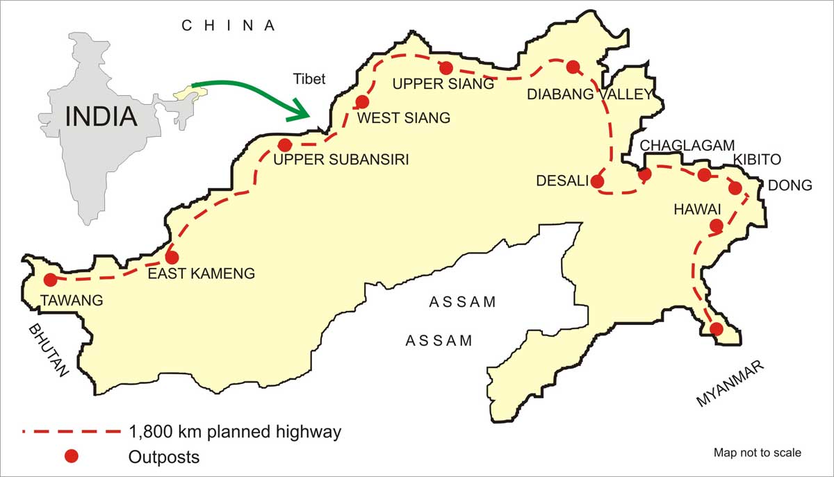 The announcement by the Government to construct an 1800 km long road running parallel to the LAC in Arunachal Pradesh (AP) is a purposive step but specious at best and is likely to remain a pipe-dream for a long time to come.
In 1997-98 there was a determined move by the then NDA government displaying a purposeful urgency in an effort to construct road axes right up to our Northern boundary. It was then planned to construct a total of eleven roads. Nine roads were in Arunachal Pradesh towards the LAC. One road was to be constructed in the then Uttar Pradesh and one in Ladakh.
The Army already has plans to build a lateral road from Kameng to Lohit half way up on the road axis from the plains leading to the LAC…
The Prospective Date of Completion (PDC) for the longest of these roads, from Along to Taksing running along the Subansari valley, and from Shyok to Daulet Beg Ouldi (DBO) was fixed for 2012. The Along-Taksing road has not yet reached the half way mark, while the Shyok-DBO road is being given a serious rethink due to the problems posed by its alignment crossing the Shyok River a number of times and because of the shifting water channels of the Shyok River in summer and may be abandoned altogether. The general apathy and the over-eagerness to put a spoke in every wheel by the Ministries of Environment and Forests resulted in inordinate delays.
The UPA government did not exempt a swathe of territory along the boundary from the requirement of complying by these norms, as has now been done by this government. Today the number of ‘strategic’ roads planned to be constructed is around 79. Most of these are in Arunachal Pradesh.
The geographical peculiarity of AP is that the river valleys and the mountain ranges in the State run more or less in a North-South alignment. Between the Kameng sector in the West and the lower Subansari, in the center, there is a vast swathe of land that is unassailable. The major rivers east of Kameng sector are Kameng, Kamla, Kurang, Subansari, Shyom, Siang, Dibang, and Lohit. These rivers have their source in the North in the glaciated regions along the watershed and some north of the watershed too. Geomorphologically, the rivers have a huge drainage basin and are fed by numerous turbulent tributaries. The volume of water and the current of these rivers, particularly in the monsoon season is awesome. As a consequence these rivers have created deep gorges along their course down to the plains.
The land belongs to the tribal people, so the government cannot acquire the land without the explicit consent of the people.
The Army already has plans to build a lateral road from Kameng to Lohit half way up on the road axis from the plains leading to the LAC, traversing up and down the valleys and the mountain ranges running on either side of the river valleys. That would, in rough terms, mean going up and down 16 mountain ranges and crossing eight major rivers. As such this proposal has not progressed beyond an expression of a ‘desire’. A similar lateral road alignment nearer the LAC would entail equally formidable engineering challenges. The additional ones being those that are posed by the altitude which would be greater, the river gorges encountered would be more numerous and requiring innovative solutions. Also, overall, the resources required would be enormous.
What ails the whole process of constructing of roads in these remote areas is the paucity of resources and multiplicity of agencies all operating insulated from the other with their own limited agendas. Just to list out some of these – Border Area Development Project which also includes roads, Pradhan Mantri Gram Sadak Yojna, North East Council funding roads, state Government, Army with its General Staff Roads, Indo-Tibetan Border Police with its own set of requirements and Special Accelerated Road Development Programme of the North East Region and more. Agencies that construct and maintain these roads range from Border Road Organisation, National Highways Authority, CPWD, PWD and even private contractors. Who coordinates this effort is not known and if some coordination is taking place it is fortuitous and not planned. The Minister of State with independent charge of the North East would be the most suitable hub to coordinate funding and development of these roads.
Some of the peculiar problems faced in the construction of roads in the Himalayan belt is due to the structure of the lower hill ranges and due to the quantum of the precipitation in the monsoon season. Add to this the restrictions imposed by the Environment and Forest Ministry, the procedures for procurement of equipment and the process of acquisition of land and there emerges this unassailable stonewall. One petty unconcerned, haloed and ordained interpreter (colloquially referred to as babu) of Rules and Regulation of the Government of India can stall a gigantic project.
As regards China’s pique to the proposal of construction of this road it is maladroit and kitsch. Obviously the road is not being aligned along the watershed! It seems to be China’s periodic urge to regurgitate on the AP issue.
The State of Arunachal Pradesh has other peculiar problems. The land belongs to the tribal people, so the government cannot acquire the land without the explicit consent of the people. Further, the construction agencies cannot import labour due the laws in place to protect the fragility of the demography. The local labour is inadequate and unskilled. The restriction on quarrying has made the construction agency hostage to the quarrying mafia. The BRO is hampered in procuring modern equipment due to the internal strife between the army element and the cadre of directly recruited civilian engineers – the country be dammed. Procedurally too, there are impediments.
The roads where the damage involves washing away of the initial formation cutting and thus entailing fresh formation cutting, becomes a new road. The whole process to seek clearance for this new road is to be initiated and it takes anything from two-three years. The monsoon does destroy the existing roads every year. The repair and maintenance resources are the same as those for an ongoing new construction. As a result the resources are diverted from the new construction to repair the damaged roads. This process takes its toll on the PDC. These are not mundane procedural wrangles that can be glossed over by the highest decision making bodies, but require urgent amendments to ensure such projects do not get stalled by these tentacles that seem to be self-generating.
As regards China’s pique to the proposal of construction of this road it is maladroit and kitsch. Obviously the road is not being aligned along the watershed! It seems to be China’s periodic urge to regurgitate on the AP issue. But it is also tantamount to gross interference in the development process of a sovereign nation. In a similar genre they will have objection to construction of roads in the hinterland, dams on the rivers for hydel-power generation, and every other project connected with development in the State. India too can raise issue with regard to Chinese construction activities in Aksai Chin since the area is Indian territory captured by the Chinese. Taiwan has cocked a snook at the Chinese for over 60 years, India can do the same when it comes to AP.
About the Author
 Lt Gen JS Bajwa, Editor Indian Defence Review and former Chief of Staff, Eastern Command and Director General Infantry. He has authored two books Modernisation of the People's Liberation Army and Modernisation of the Chinese PLA
No comments:
Post a Comment