By Air Cmdr PC Chopra
02 Aug , 2016
 The large porous and underdeveloped border could also be turned into a border of peace and progress. The pro-democracy movement and Myanmar’s integration with Western economies, would give a much needed push towards studying Western concepts and learning English. As such, India needs to open, near the Indo-Myanmar border, a large number of schools, colleges and a university specialising in teaching English and democratic concepts and shared cultures. Students with special passes should be able to just walk over and attend classes in India. The area is especially suited for Myanmar’s citizens near and around the capital Naypyidaw in Northern Myanmar, where the need is greatest. This matter needs to be pursued with the present government on priority. This would enhance India’s soft power status as also protect her interests.
The history of this region is a saga of independence movements, military dictatorships, insurgencies, externally sponsored low intensity armed conflicts and tribal uprisings…
Very few officials in the corridors of power in New Delhi know anything about Walong, the Easternmost town of India on the tri-junction of the China-India-Myanmar border. It was the scene of fierce fighting during the Sino-Indian conflict of 1962. Lesser still, the powers that be in Delhi do not know that the distance from New Delhi to Walong is greater than the distance from Walong to Bangkok and Hanoi. New and exciting developments, opportunities missed and made, are taking place in this region. A new network of roads, railway lines, airstrips and air-corridors are being planned, developed and strengthened. This will have a profound effect on the future of India and its ‘Look East’ policy. These developments will also have far reaching consequences on the defence of these far flung borders, bring us face to face with China and Myanmar and herald a defence and economic transformation in the region. The author has flown more than a thousand hours in the area and landed at all the helipads, airstrips, airfields, Indian Air Force stations, army formations and knows the area like the palm of his hand.
The North-Eastern borders of India run from:
The high altitude snow-covered Himalayan ranges interspaced with densely covered forests where fast flowing tributaries of the mighty Brahmaputra converge on the plains of Assam to form a huge waterway to the Bay of Bengal.
As the border runs Southwards, through the Eastern boundaries of Nagaland and Manipur with Myanmar, snowy ranges peter down to low mountain valleys running North to South (Arakans) and covered with thick rainforests, so thick that one cannot see the ground for hundreds of square kilometres.
Further Southwards, the border opens to undulating terrain with rivulets, steep ravines and gulleys on the Mizoram-Myanmar border and brings India’s Eastern borders even closer to Sitte, (Akyab) Mandalay and Rangoon.
China is heavily dependent on external oil, and 80 per cent of its oil imports pass through the narrow Strait of Malacca which is a natural choke point for future enemies…
Background
The history of this region is a saga of independence movements, military dictatorships, insurgencies, externally sponsored low intensity armed conflicts and tribal uprisings. In the early twentieth century, the British had hoped that Burma might be the back door entry to China. However, for the Burmese, being under British rule led instead to a much closer connection with India. Rather than making Burma a separate colony like Ceylon (now Sri Lanka), Burma was annexed to British India and governed as another province not different from Punjab or Bengal. Rangoon was turned into an Indian city.
Three years after the end of WWII, the British were in no mood to fight an insurgency by communists, and a radical nationalist movement in Burma. The Indian government refused the British offer to send Indian troops to quell the revolt and restore order. So Burma became an independent republic on January 04, 1948. In 1955, India refused the US offer of a permanent seat in the UN Security Council, the one we covet now, to safeguard future “Chinese Interests”. After the Burmese military takeover in 1962, the large Indian community was expelled without a protest, and Burma cut off from the outside world.
Today, China is heavily dependent on external oil, and 80 per cent of its oil imports pass through the narrow Strait of Malacca which is a natural choke point for future enemies. Here, Myanmar is the key, providing the vital China’s land link to the Bay of Bengal. For India, Myanmar is a natural land bridge between India and ASEAN. More and more, India is looking towards the East for trade, natural resources and defence options.
After the Burmese military takeover in 1962, the large Indian community was expelled without a protest, and Burma cut off from the outside world…
Indo-Myanmar-China Border
The region of Assam, Northern Myanmar and Yunnan (China), has many racial and cultural similarities. It also hosts many diverse tribes, with varying ethnic backgrounds and religions which are at war with themselves and with the nations of which they are a part. The area is covered with dense forests and though rich in natural resources, is backward. Of late, to this heterogeneous mix is added the great power rivalry. In this cauldron, a new network of roads, railways, waterways and air routes is being planned and implemented.
India-Myanmar Links
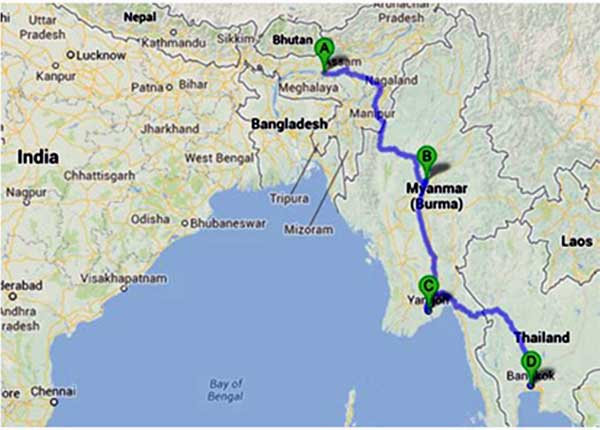
India is to open a four lane motorway to allow traders and tourists to drive from its Eastern state of Assam into Myanmar, Thailand, and eventually to Kampuchia and Vietnam. This new tri-lateral highway is aimed at creating a new economic zone ranging from Kolkata on the Bay of Bengal to Ho Chi Min city on the South China Sea. A deadline of end 2016 (likely to be extended) to complete a super highway, linking Guwahati in Assam, to Myanmar’s border with Thailand via Mandalay and Rangoon is on the anvil. The road is the main part of a plan to open the Mekong–India corridor, to link the world’s second fastest growing market – India, with the new Asian tiger economies in Indo-China.
Plans to open the new economic zone which bypasses China have been given the green signal after the lifting of sanctions against the military regime in Myanmar. For India, the new highway will open up oil and gas opportunities off the coast of Myanmar, as well as easier access to Japanese products ‘Made in Thailand’. This would also bring new development/wealth to poor and marginalised Northeastern States. A two lane highway connecting the Indian border town of Moreh with Mandalay 375 miles – Rangoon another 375 miles has already been built. The final aim is to have road access from Guwahati to Bangkok.
China’s increasing engagement with the Myanmar military junta had made India uneasy…
Defence Aspects
The Moreh (India) – Tamu (Myanmar) – Mandalay portion will make it easier for the security forces of both countries acting in coordination to take on armed insurgents such as the Naga tribesmen in India and the Kachin rebels in Myanmar. Earlier defence cooperation in the form of large scale arms transfer had not been found effective as it often ended up in the wrong hands much to the embarrassment of India. Better ends can be ensured by training of Myanmar armed forces in India, joint exercises in the actual area of operations and commonality of arms and ammunitions.
Tactically, effective patrolling, border fencing at key locations, use of drones, satellite imagery for tracking infiltrating routes and joint border operations between India and Myanmar armed forces with the clause of joint defence rather than ‘hot pursuit’ would go a long way to ensuring peace and tranquility in border areas. As such there is a huge potential for strategic and tactical military cooperation which enables Myanmar to provide stability to its ethnic groups, which in turn, will secure India’s NE states.
Connecting India by sea to Northern Myanmar, the ‘Kaladan’ multi-modal transit transport model will connect Kolkata with Sittwe (Akyab) in Myanmar and then further to Champai in Mizoram, via a river/road project. This will connect the hinterland of Kolkata to Northern areas in Myanmar as also connect the relatively landlocked state of Mizoram to Myanmar and further on to India by sea. The project is planned for completion by 2016 (likely to be extended). Aizawl/Champai border towns in Mizoram are situated in a strategic location near the Bangladesh-India-Myanmar border and will provide the planned trade link to the Bay of Bengal via Sittwe and further on to the urban-industrial complex of Mandalay/Rangoon.
Here it may be noted that the shortest link from Lunghan (Southern Mizoram) on NH 54 to the Bay of Bengal is via Chittagong (Bangladesh) – a total distance of just 75 miles. The Indian government needs to connect Kolkata via Chittagong, to Mizoram and on to Kaletwa (Southern Myanmar) by road/river an aspect that has not been seriously considered. It is the most favourable for the shortest distance to the sea from landlocked Mizoram and better transit and trade prospects with Myanmar.
Power Play
China’s increasing engagement with the Myanmar military junta had made India uneasy. India believes that its national interests demand that the Bay of Bengal which straddles Myanmar does not become a hot bed of interference by foreign navies. New Delhi keeps a close watch on the Cocoa Islands in Myanmar where China has upgraded its radar/naval auxiliary facilities. The Ganges-Mekong initiative between India, Myanmar, Thailand, Cambodia, Laos and Vietnam envisages the development of closer relations between these countries to counter balance China and includes a direct East-West Corridor road and air link.
Ever since the civilian government has taken over power in Myanmar, China faces a conundrum…
Meanwhile, the juggernaut of China moves rapidly. China’s Yunnan province is already connected by a highway with Myanmar’s Rangoon. Construction of a gas and oil pipeline is in progress which will transport oil and gas from Africa and the Middle East via Myanmar directly to Kunming in Yunnan in China. China is reactivating the old, General Stillwell’s Second World War ‘Ledo Road’ from Kunming in China to Myitkyina in Northern Myanmar and onward to Ledo in India.
Yet, ever since the civilian government has taken over power in Myanmar, China faces a conundrum. China wants to remain on good terms with the Kachin rebels (KLA) who share ethnicity with the minorities in Yunnan and supporting Myanmar’s military fighting the KLA. This has led to border security issues. Recent peace talks have also brought in the US much to the chagrin of China. Of late, Japan has started funding construction of roads/railways by the Myanmar government.
China – Myanmar Border
Meng`a is one of the main entry point from China into Myanmar through Bangkang, the capital of Special Region No. 2. (See Map) . The Chinese government is worried that fighting between the United WA State Army (USWA), the Kachin Independence Army (KIA) and the military junta could break out in a protracted and bloody struggle. This could spill over into Yunnan in China and become a nightmare for the Chinese. Recently, Myanmar’s army mounted a ground offensive against these ethnic Chinese militias and 37,000 sought refuge in China. Exchange of gunfire and border skirmishes erupted. China is sympathetic to the ethnic militias who have evolved from the Communist Party and received training and arms from it. Myanmar’s junta does not like the Chinese interference and providing shelter to the militias.
China is sympathetic to the ethnic militias who have evolved from the Communist Party and received training and arms from it…
Another headache for China is the large-scale drug trafficking in this unstable region. China’s dilemma is to have good relations with the military junta for building gas and oil pipelines to the Bay of Bengal, by-passing the chokepoint of the Straits of Malacca, as also downplaying its role with the rebels. The entry of democratic Aung Kang Suu could complicate matters further.
India’s Role
India has always been on the defensive vis-à-vis China. For once, India needs to take a proactive/offensive role by injecting arms, money and training to slow down the construction of gas/oil pipelines and road projects, the aim being to provoke instability in the soft underbelly of China. India’s borders (airfield at Vijaynagar) is projecting like a knife/bludgeon in the highly forested and underdeveloped areas of Myanmar and China.
India’s problems with the Naga insurgents, on a medium term basis would be to assist Myanmar and integrate with Naga elements on its side of the border. At the same time accelerate the process of assimilation of the Nagas on the Indian side. The principle that borders cannot be changed but made irrelevant needs to be pursued to solve the Naga problem.
The large porous and underdeveloped border could also be turned into a border of peace and progress. The pro-democracy movement and Myanmar’s integration with Western economies, would give a much needed push towards studying Western concepts and learning English. As such, India needs to open, near the Indo-Myanmar border, a large number of schools, colleges and a university specialising in teaching English and democratic concepts and shared cultures. Students with special passes should be able to just walk over and attend classes in India. The area is especially suited for Myanmar’s citizens near and around the capital Naypyidaw in Northern Myanmar, where the need is greatest. This matter needs to be pursued with the present government on priority. This would enhance India’s soft power status as also protect her interests.
India’s problems with the Naga insurgents, on a medium term basis would be to assist Myanmar and integrate with Naga elements on its side of the border…
Conclusion
As new plans are being made, earlier plans are being realised. There are different scenarios for the region. One, Western sanctions stay in place and Myanmar remains the only country in the region without access to Western technology and learning but grows economically. This will be mainly as a supplier of primary commodities to China, and as China’s corridor to the Indian Ocean Region. Chinese interests are served in the short term but medium, long term, anti- Chinese sentiment increases (already significant) and the relationship paralysed. India’s plans to ‘Look East’ and establish road, rail corridors to ASEAN remain mainly on paper. China’s tightening hold, alarms India and other states in the region and this fuels new and old rivalries, even as trade increases. Conflicts in Northeastern India and Northern Myanmar remain unresolved, leading to a new cycle of armed insurgencies. Cross border problems, gun running, narcotics trafficking and spread of infectious diseases increase. A dangerous crossroads is being established.
There is another happy scenario of a quick end to the Myanmar sanctions. Development is more balanced, reducing poverty oriented, and more democratic. Ceasefires and insurgencies are transformed into sustainable peace. Minority and ethnic grievances are addressed. Peace comes to Northeastern India with the armed forces confined to barracks. Tourism and trade flourish with a rising middle class. Northeastern India becomes a granary of India, and a powerhouse for development and growth. Borders are opened paving the way for the boon of Asian development.
© Copyright 2016 Indian Defence Review
No comments:
Post a Comment