Source Link
 Henry T. Colebrooke (1765-1837), who succeeded Jones as the Society’s president, was not only a champion of Sanskrit literature but also carried out topographic surveys. Indeed, he was the first person in 1816 to designate the Himalaya (based on his observations of Dhaulagiri) as the world’s highest mountain range, surpassing the Andean summit of Chimborazo (in today’s Ecuador), which was then believed to be the highest peak. Early geological and geographic papers on India and the Himalaya were published in the Asiatic Society’s periodicals: Asiatic Researches (1798-1839) and Journal of the Asiatic Society of Bengal (1832-) (the latter was a continuation of Gleanings in Science, launched by James D. Herbert in Calcutta in 1829). A sister institution, the Asiatic Society of Bombay (initially called the Literary Society of Bombay), was founded by Sir James Mackintosh in 1804 (which merged with the Bombay Geographical Society in 1873 and the Anthropological Society of Bombay in 1896).


Posted by alpinedrome in Uncategorized
Kipling popularized the term ‘Great Game’ for rivalries and conflicts among Britain, Russia, France, and China to gain political and economic control of the Indian subcontinent and central Asian highlands during the nineteenth and early twentieth centuries. Much of the literature on the Great Game, for instance Peter Hopkirk’s The Great Game (1990), has focused on its political history. This article deals with the topographic surveys, geological mapping and geographic exploration of the Himalaya as a direct consequence of the Great Game. This subject offers a fascinating field of research into the history of science and also sharpens our knowledge of Himalayan geography and geology. Here we particularly focus on how British institutions and personalities in India played a paramount role in the mapping and exploration of the Himalaya-Tibetan region. (A number of Frenchmen, Germans, Italians, Swiss and Russians contributed to this venture as well, but are not discussed in this article.)
The East India Company and Governor-General of Bengal
Although the British East India Company’s activities in India date back to the early seventeenth century, the year 1765, when Captain Robert Clive (1725-1774) forcefully obtained the sovereign rights (‘Diwan’) of Bengal from the Indian Mogul emperor Shah Alam, and the year 1772, when Warren Hastings (1732-1818) became the first Governor-General of Bengal, are starting points in our discussion because these events ushered in systematic exploration activities in the Indian subcontinent and the Himalayan region supported by both political and commercial entities based in Calcutta (Kolkata). This situation remained intact until 1858 (a year after the Indian Mutiny) when the seat of power moved to Delhi, and British Raj came under direct rule of the British Crown and Parliament represented by the India Office in London, and Governor-General of India and the Queen’s Viceroy in Delhi.
In 1767, Clive appointed Major James Rennell (1742-1830) as the Surveyor-General of Bengal. Sometimes called the British ‘father of Indian geography,’ Rennell prepared the Bengal Atlas and the Map of Hindoostan. (He was succeeded in 1794 by Robert Colebrooke.) In the same year, Clive also sent Captain Kinloch on a military mission to Nepal, who brought back the first sketch maps of that country although his army was defeated. In 1774, Hastings dispatched George Bogle (1747-1781) for a year-long trip to Bhutan and Tibet. His journey was followed in 1783 by that of an army officer and Hastings’ cousin, Samuel Turner (1826-1868), whose Account of an Embassy to the Court of the Teshoo Lama in Tibet (1800), remained for nearly a century the standard European book on Tibet because that country closed its borders to foreigners. In 1792, Hastings sent Colonel William Kirkpatrick to Nepal (to help the Nepalese court with a minor war with Tibet). The first Englishman to visit Kathmandu, Kirkpatrick gathered geographic information about Nepal in his Account of the Kingdom of Nepaul (1811). (In this expedition, John Gerard prepared a route map to Kathmandu.)
During 1801-1804, Charles Crawford, then Surveyor-General of Bengal, mapped parts of Nepal, and during 1802-1803, Francis Buchanan Hamilton (1762-1829), a physician and geographer, visited Nepal with the military mission of Captain Knox. Although like Kirkpatrick before him, Hamilton stayed only in the Kathmandu valley, he derived much information from the native people, and thus published An Account of the Kingdom of Nepal and of the Territories Annexed to This Domain by the House of Gorkha (published in 1819), which also included the results of Colonel Crawford’s mapping.
In 1808, Robert Colebrooke planned to explore the source of the Ganga (Ganges) in Garhwal; however, he could not partake in the expedition due to illness and died in the same year. John Garstin succeeded him as Surveyor-General of Bengal. The expedition work was continued by William Webb, Captain Felix Raper, and Hyder Hearsey, who produced the first map of the Bhagirathi valley. They also sent Hearsey’s Hindu munshi (assistant) to Gangotri and incorporated his observations in their final report (published in Asiatic Researches, volume 11, 1810), which demonstrated that the source of Ganga lay within the Himalaya, not in Lake Manasarovar in southern Tibet, as was then widely believed.
In 1811, Thomas Manning (1772-1840) became the first Englishman to enter Lhasa. (His travelogue as well as that of Bogle were not printed until 1876 when Sir Clements Markham, a geographer at the India Office in London, published them in a single volume, Narratives of the Mission of George Bogle to Tibet and the Journey of Thomas Manning to Lhasa, which became so popular that a second edition was brought out in 1879). During 1811-12, William Moorcroft and Hyder Hearsey made their first trip to Lake Manasarovar (reported in Asiatic Researches, volume 12, 1816).
After a triumphant war with the Gurkhas of Nepal in 1814-16, the British fixed the western boundary of Nepal along river Kali; thus Garhwal and Kumaun regions of the Himalaya came under British control. (These regions were included in what was initially called the Ceded and Conquered Provinces, then the Northwestern Provinces in 1836, the United Provinces of Agra and Oudh in 1902, and finally Uttar Pradesh, meaning ‘northern province’ in 1950. In 2000, the western part of Uttar Pradesh became a separate state called Uttarakhand, also meaning ‘northern province.’) The Scottish painter and travel writer, John Baillie Fraser, was the first European to reach Gangotri in 1815; his Journal and paintings of the Satluj and Ganga valleys were published in 1820. From 1816-1820, William Webb spent five lonely years surveying Kumaun (he determined the height of Peak XIV or Nanda Devi as 25,669 feet, just 24 feet higher than today’s measurement), Laidlaw served as mineralogist to the Survey of Kumaun (1817-1821), and John Hodgson (Surveyor of the North-West Provinces) and James Herbert mapped Garhwal. In 1821, in a controversial move, John Hodgson (several years junior to Webb) succeeded Colin Mackenzie as Surveyor-General of India, and the following year, Webb resigned from the Survey and returned to England. From 1823-29, Herbert served as the Geological Surveyor of the Himalayan Mountains. Meanwhile, the three brothers, James, Alexander and Patrick Gerard (nephews of John Gerard), made their specialty the exploration of the Satluj valley and Shimla Hills (Himachal).
In 1817 Ranjit Singh, Maharaja of the Punjab, conquered Kashmir, and thus the British, through their friendly relationship with Ranjit, could explore Kashmir, Ladakh and Baltistan. William Moorcroft (1767-1825) was one of the greatest Himalayan explorers of the nineteenth century. During 1819-1825, he and George Trebeck (a geologist and surveyor from Calcutta) journeyed Ladakh, Kashmir, Baltistan and Afghanistan. Although both of them died mysteriously on their way back from Afghanistan, their painstaking report was preserved and published in two volumes, Travels in the Himalayan Provinces of Hindoostan and the Punjab (1841).
The Anglo-Burmese war of 1824 increasingly drew the attention of the East India Company to the northeastern parts of the Himalaya. Richard Wilcox and James Burlton were pioneers of exploring Assam and the Brahmaputra valley during 1825-1828. Wilcox’s report was published in Asiatic Researches (volume 17). An 1830 survey of Darjeeling by James D. Herbert and James Grant appeared in the Journal of the Bengal Asiatic Society (volume 2, 1831).
During 1831-33, Alexander Burnes (1805-1841), a political agent-cum-explorer travelled across the Punjab and Afghanistan as far north as Bokhara. One of his companions and a sailor with Indian Navy, John Wood (1812-1871), reached the source of the Oxus river in 1838. Burnes in 1834 (Travels into Bokhara) and Wood in 1841 (A Journey to the Source of the River Oxus) published their travelogues. Burnes, who eventually became Britain’s political agent in Kabul from 1836 to 1838, also documented his observations in Cabool, published posthumously in 1842.
From 1831-1854, Captain Proby Cautley (1802-1871) engineered the construction of the Ganga Canal in order to divert the Ganga water into the Doab (‘two water’) area, between the Yamuna and the Ganga. The Ganga Canal project (described in Cautley’s 1860 book The Ganges Canal) put an end to the serious and frequent famines that hit this region. As a result of surveys and excavations made for the Ganga Canal, the Siwalik mammalian fossils were unearthed in the Siwalik Hills near Haridwar (named after Hari or Lord Shiva). Cautley and the paleontologist Hugh Falconer (1808-1865), who studied the Siwalik fossils for two decades, gave the name of ‘Siwaliks’ to the sedimentary rocks of the hills in which the fossils were found.
In 1846, Henry Strachey (1816-1912), and two years later his younger brother Richard Strachey (1817-1908), visited Lake Manasarovar via Kumaun. Like Moorcroft and Hearsey before him, Henry Strachey disguised himself as a Hindu pilgrim; his full report (On The Physical Geography of Western Tibet) was published in 1853. He discovered that the watershed of the Indian rivers did not correspond with the Great Himalayan peaks as seen from India, but lay beyond the Himalaya. Richard Strachey mapped the geology of Kumaun and southern Tibet, and determined the position of Mount Kailas and calculated its height to be 22,000 feet (only 28 feet lower than later measurements). His important works were published in the Quarterly Journal of Geological Society and Journey of Royal Geographic Society in London in 1851.
Following the 1845-1847 wars with the Sikhs, the British annexed the Punjab. In 1847-48, Thomas Thomson made a journey to western Himalaya and Tibet, and scaled the Karakoram pass. His account (Western Himalaya and Tibet) was published in 1853.
The first attempt to present a coherent geological picture of the Himalaya was made by James D. Herbert, Deputy Surveyor-General of India, whose paper was published in 1842 (nine years after his death) (Journal of Asiatic Society of Bengal, volume 11, 1842, and map in volume 13) although his field work was conducted in 1818. Based on his observations in the Satluj and Kali valleys, Herbert divided the Himalayan rocks into the ‘primary’ formations (central gneiss and schist) and the ‘secondary’ formation (sandstone). He also noted that these rocks formations dip towards the central gneiss, and that gneiss lies on top of the schist, and schist on top of the sandstones — an arrangement which was not true stratification, but (in his opinion) produced by ‘concretionary action.’
Brian Hodgson (1800-1894), a naturalist and British agent who lived in Nepal, also published general views on the geography of the Himalaya. In his 1849 paper (Journal of Asiatic Society of Bengal, volume 18), Hodgson argued that numerous Himalayan streams flow from the snowy peaks at right angle to the strike of the Himalaya, but converge to form huge rivers close to the plains. He thus divided the Himalaya into spurs on the basis of these transverse river systems, and mistakenly thought the Himalaya did not continue as a single mountain range.
Sir Joseph Dalton Hooker (1817-1911) explored Sikkim and Bengal during 1848-52 and published a fascinating account, Himalayan Journals, in 1854. In the same year, the first geological map of India was brought out by George B. Greenough (1778-1855, founder of the Geological Society of London), based on information and maps provided by British explorers working in India. Also in 1854, Alexander Cunningham (1814-1893) published his famous book, Ladak: Physical, Statistical and Historical, in which he introduced the term ‘trans- Himalaya’ for a range immediately beyond the Himalaya (Cunningham eventually rose to become the first Archaeological Surveyor of India).
The Asiatic Society of Bengal
The word ‘orientalism’ appeared in the English language in 1769. In British India, orientalism was supported by Warren Hastings and like- minded scholars, notably Sir William Jones (1746-1794), who felt the need and opportunity for systematic studies of India rather than relying on travel tales of a few adventurers (for details see O.P. Kerjariwal’s The Asiatic Society of Bengal and the Discovery of India’s Past, 1988). This led to the establishment of the Asiatic Society (of Bengal) in Calcutta in 1784 by Jones who remarked that ‘the intended objects of the Asiatic Society were Man and Nature — whatever is performed by the one, or produced by the other — within the geographic limits of Asia, with Hindustan as a centre’.
Henry T. Colebrooke (1765-1837), who succeeded Jones as the Society’s president, was not only a champion of Sanskrit literature but also carried out topographic surveys. Indeed, he was the first person in 1816 to designate the Himalaya (based on his observations of Dhaulagiri) as the world’s highest mountain range, surpassing the Andean summit of Chimborazo (in today’s Ecuador), which was then believed to be the highest peak. Early geological and geographic papers on India and the Himalaya were published in the Asiatic Society’s periodicals: Asiatic Researches (1798-1839) and Journal of the Asiatic Society of Bengal (1832-) (the latter was a continuation of Gleanings in Science, launched by James D. Herbert in Calcutta in 1829). A sister institution, the Asiatic Society of Bombay (initially called the Literary Society of Bombay), was founded by Sir James Mackintosh in 1804 (which merged with the Bombay Geographical Society in 1873 and the Anthropological Society of Bombay in 1896).
The origin of the Survey of India dates back to Rennell’s work in Bengal in 1870s; the survey work was later shifted to southern India. Following the defeat of Tippu Sultan of Mysore by the East India Company forces led by Arthur Wellesely in 1799, two survey works were initiated in southern India. The first was a route and topographic survey carried out by Francis Buchanan (1762-1829) and Colin Mackenzie (1754-1821), and the second was a geodetic survey (triangulation survey equipped with theodolites) conducted by William Lambton (1753-1823). Colonel Mackenzie became Surveyor-General of India in 1815, and assembled the Topographical and Revenue Services under his authority in 1817. Lambton’s work, the Trigonometric Survey of the Indian Peninsula, was expanded into the Great Trigonometric Survey (GTS) in 1818 when George Everest (1790-1868) succeeded Lambton. Everest was promoted to be the Superintendent of the GTS in 1823 and Surveyor-General of India in 1830.
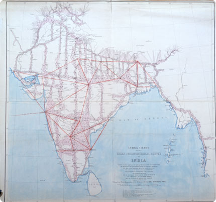
The Great Trigonometrical Survey of India
Image © Royal Geographical Society (with IBG)
By 1841, the geodetic survey of the Great Indian Arc of Meridian (about 2500-km long) from Cape Comorin (Kanya Kumari) to the Himalayan foothills in Dehra Dun was completed, and Everest retired in 1843. The Great Indian Arc became a baseline for surveying the Himalaya in the following decades. Andrew Scott Waugh (1810-1878), who succeeded George Everest, conducted the North-East Himalayan and North-West Himalayan series.

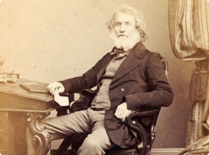
Sir George Everest (Photograph Carte de Visite)
Image © Royal Geographical Society (with IBG)
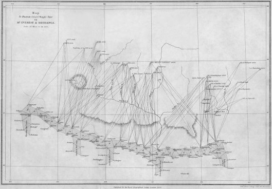
During the late 1840s, the survey was pushed into the Himalaya foothills and the heights of many peaks, including those in Nepal, were scaled by triangulation. As a result, it was discovered in 1852 that Peak XV, then estimated to be 29,002 feet tall (26 feet less than the 1955 measurement), was the world’s highest mountain. At Waugh’s suggestion (and despite George Everest’s objection), this peak was named Mount Everest (for Nepal being a closed country then, the native name of Chomolungma was unknown to the surveyors).

This is the first ever printed (Jan 1858) map that names Peak XV (as it was formerly known) as Mount Everest.
Image © Royal Geographical Society (with IBG)
During 1855-1864, the Great Trigonometric Survey began a major work in Kashmir. In charge of the survey was Thomas G. Montgomerie (1830-1878), aided by two energetic colleagues, William H. Johnson (?- 1892) and Henry H. Godwin-Austen (1834-1923). This team surveyed Kashmir as well as the Karakoram, and calculated the height of the world’s second highest peak, K2, to be 28,287 feet (overestimated by 37 feet). Godwin-Austen, a geologist-mountaineer, pioneered the mapping of the Karakoram. Montgomerie then extended his work to Garhwal and Kumaun in 1867.
In 1868, the Great Trigonometric Survey began its work in Assam, along the course of the Brahmaputra. The Assam triangulation was completed in 1878. In the same year, James T. Walker (1826-1896) was appointed Surveyor-General of India. He combined the Great Trigonometric Survey, and the Topographical and Revenue Surveys as the Survey of India, headquartered in Dehra Dun.
Sir Sidney Burrard (1860-1943) was Surveyor-General of India from 1910-1919. He ordered a re-survey of Kashmir (1909-13, led by J. Hunter and H.G. Bell) and Assam (1911-13, led by C.P. Gunter, E.B. Cardew, F.M. Bailey, H.T. Morshed, and O.H.B. Trenchard). During 1927-30 Kohistan (now in Pakistan) was surveyed by C.G. Lewis, and in 1935-38 Kumaun was re-surveyed by Gordon Osmaston.
Primary sources of information on the heroic activities and results of the Survey of India include C. R. Markham’s A Memoir of the Indian Surveys (2nd edition, 1878) and R. H. Phillimore’s Historical Records of the Survey of India (1945-1962, consisting of five volumes: I. 18th century; II. 1800-1815; III. 1815-1830; IV. 1830-1843; and V. 18441861). Popular accounts of this history are given in S. Styles’ The Forbidden Frontiers (1970), M. Edney’s Mapping the Empire (1997) and John Keay’s The Great Arc (2001).
The Geological Survey of India
Systematic geological studies of the Himalaya began with the establishment of the Geological Survey of India (GSI) in Calcutta in 1851.
The original scope of the GSI was limited to exploring India’s coal reserves. In 1936, the Government of Bengal formed a Coal Committee to study the coal supplies for use in the steamers on the Ganges. In the early 1840s, the Coal Committee’s secretary, John McCelland, contacted the Government of Bengal and eminent geologists in Britain, and persuaded them to setup a proper geological survey in India. In 1846, David H. Williams was appointed as Geological Surveyor to the East India Company. Williams worked for three years in India, exploring coal reserves. He died of illness in 1848. John McCelland took his place until 1850, and finally in 1851, Thomas Oldham was appointed in Calcutta as a Williams’ successor.
Thomas Oldham (1816-1878), a former professor of geology at Dublin and a local director in the Geological Survey of Ireland, was the real architect of the GSI, and aptly gave himself the title of the Superintendent of the Geological Survey. During his 25 years of tenure, GSI became one of the finest geological surveys in the world. Oldham hired many excellent geologists, including the two brothers John G. Medlicott and Henry B. Medlicott (1829-1905, served 1854-1887), the two brothers William T. Blanford (1832-1905; served 1855-1882) and Henry F. Blanford (1834-1893; served 1855-1862), William Theobald (served 1848-1881), R. Bruce Foote (1834-1912; served 1858-1891), Arthur B. Wynne (1835-1906, served 182-1883), Ferdinand Stoliczka (1838-1874; served 1862-1874), Frederick R. Mallet (1841-1921; served 1859-1889), Ottokar Feistmantel (1848-1891; served 18751885), Wilhelm Waagen (served 1870-1875) and Richard Lydekker (1849-1915; served 1874-1883). The reputed publications of the GSI, Memoirs of the GSI (1856~), Paleontological Indica (1865~), and Records of the GSI (1868~) were also launched by Oldham.
GSI geologists carried out pioneer work in the Himalaya even though field work conditions were then very difficult. Medlicott single- handedly worked out the geology of the Siwaliks between the Ravi and Ganga rivers and discovered the Main Boundary Fault between these sediments and the Lesser Himalaya to the north (GSI Memoir, 1864, 212 pp.). (Medlicott succeeded Oldham as Director of the GSI in 1878.) Stoliczka mapped Spiti (GSI Memoir, 1865, 154 pp). (Stoliczka eventually died of altitude sickness in Ladakh, the first Himalayan geologist to die in the field.) Mallet’s 50-page GSI Memoir (1875) still serves as the foundation of geological knowledge on Darjeeling. Wynne mapped the Salt Range (GSI Memoir, 1878, 413 pp). Lydekker mapped Kashmir and Chamba (GSI Memoir, 1883, 344 pp). Carl Griesbach (an Austrian geologist who joined GSI in 1878) produced an excellent report on the Central Himalaya (GSI Memoir, 1891, 232 pp). (Griesbach became Director of the GSI in 1894). Charles Middlemiss (who served at the GSI from 188-1917) mapped the Hazara area (GSI Memoir, 1896, 302 pp), and his report (GSI Memoir, 1910) on the 1905 Kangra earthquake ran 409 pages, probably still a record for a single- author report on a single earthquake!
During 1879-1887, A Manual of the Geology of India was published by the GSI, bringing together a vast geologic knowledge of India and Himalaya. It consisted of four parts: Part I. Peninsular India (by H.B. Medlicott and W.T. Blanford, 1879), Part II. Extra-Peninsular Area (H.B. Medlicott and W.T. Blanford, 1879-1881); Part III. Economic Geology (V. Ball, 1881); and Part IV. Mineralogy (F.R. Mallet, 1887). A second edition was published in 1893, revised by Richard Dixon Oldham (1858-1936), Thomas Oldham’s son.
The twentieth century began with major changes in the GSI. Within half-a-decade several outstanding figures passed away, including C.A. McMohan in 1904, W.T. Blanford and H.B. Medlicott in 1905, A.B. Wynne in 1906, C.L. Griesbach in 1907 and R. Strachey in 1908, and a new generation of geologists continued the mapping and studies of the Himalaya. Thomas H. Holland (1868-1947) succeeded C.L. Griesbach as Director of the GSI (1903-1910). H.H. Hayden published excellent works on Spiti (1904), Tibet (1907), northern Afghanistan (1911) and Gilgit (1915). (Hayden, GSI Director from 1910 to 1921, was killed by a rock fall in the Alps in 1923. He was, in turn, succeeded by Sir Edwin Pascoe.) Henry Guy E. Pilgrim (1875-1943) proposed a stratigraphic classification of the Siwalik Group (1910, 1913), which is still used to this day. In a series of publications in Paleontological Indica, Carl Diener and Frederick R.C. Reed made detailed studies of faunal fossils from the Tethys sediments of Kashmir, Spiti and Kumaun. During the 1930s, D. N. Wadia in Kashmir, Ladakh, and the Punjab, William D. West in Himachal, and John B. Auden in Garhwal produced some of the finest works in Himalaya geology.
Two important GSI publications in the first half of the twentieth- century summarised the knowledge of Himalayan geology: (1) A Sketch of the Geography and Geology of the Himalaya Mountains and Tibet (1907) by Sidney G. Burrard and Henry H. Hayden (revised by S.G. Burrard and Alexander M. Herron in 1934); and (2) the third edition of Manual of Geological of India and Burma (3 volumes) revised by Edwin Pascoe (Director of the GSI from 1921-32), who worked on the new edition during his retirement but the publication was delayed until 1956.
The last British Director of the GSI was D.N. West, who served only from 1945-47. (Dr. West later joined Saugar University in 1955, and developed a geology department, serving there until his death in 1994.) The first Indian Director of the GSI was M.S. Krishnan (18981970), author of a well-known textbook, Geology of India and Burma (1943, fourth edition in 1960). His tenure began in the same year as a new journal, Indian Minerals, joined the family of GSI periodicals. N.P. Chaudhuri’s Story of GSI 1851-2001 offers a comprehensive account of the GSI’s history.
The Pundit Missions
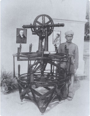
One of the remarkable achievements of Thomas Montgomerie was the training and dispatch of the ‘Pundits’ to explore and map the southern part of Tibet. The Pundits, who journeyed in disguise as traders or pilgrims, were native Himalayan men. Often referred to as British spies, the Pundits indeed advanced the geographic knowledge about the courses of the great Himalayan rivers, the Trans-Himalayan Range, and Lhasa. Accounts of their life and geographic work, especially of Nain Singh Rawat (No.1) and his relatives Mani Singh, Kalian Singh, Kishen Singh and Kinthup, make some of the most fascinating and heroic stories of Himalayan exploration during the 1860s-1890s. These men covered a vast mountainous region from river Kabul on the east to the Yangtze on the west, and from Darjeeling as far north as Kashgar. For detailed information see I.S. Rawat’s Indian Explorers of the 19th Century (1973), D.J. Waller’s The Pundits (1990), and Jules Stewart’s Spying for the Raj (2006).
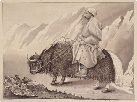
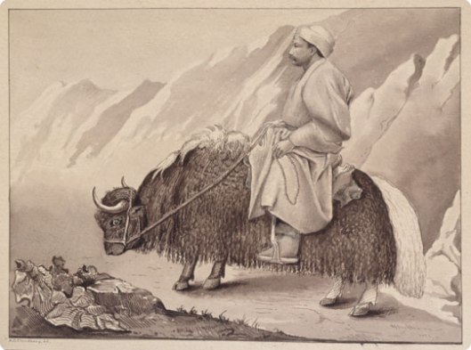
This painting shows the pundit, Sarat Chandra Das, travelling incognito on a yak in 1879. He is crossing the Donkhya Pass in India at 18,000 feet (5,486m).
Image © Royal Geographical Society (with IBG)
Colleges and Universities
According to Larwood (‘Science in India before 1850′ in British Journal of Educational Studies, 1958) geology and mineralogy were taught at the East India Company’s colleges. This education was intensified in the second half of the nineteenth century as the need for coal and other mineral resources in British India grew. In 1854, Henry B. Medlicott became Professor of Geology at Thomson College (founded in 1847, and later named as the Roorkee Civil Engineering College). A more systematic effort in geology education was made at the Presidency College in Calcutta (originally established in 1817 as the Hindu College by Raja Ram Mohan Ray, and changed to Presidency College in 1855). Henry Blanford was the first Professor of Natural Science at Presidency College, and Himalayan geologists from the Geological Survey of India often taught there. In 1892, an independent department of geology was opened at the college, with Sir Thomas Holland as its first professor. The University of Calcutta was founded in 1857 as an affiliating body of numerous colleges in north India (modeled on the University of London). One of these colleges was the City College (Amherst College), where Sashi Bhusan Day obtained an M.A. degree in geology under the supervision of Thomas Holland (the first Indian to do so). Presidency College in Madras (Chennai) was founded in 1840 and formed the core of the University of Madras (1857). It was also a centre of geology education (as part of the natural science) and its independent geology department began in 1910. The University of Jammu grew out of the Prince of Wales College (later Government Gandhi Memorial Science College) where geology education began in 1907 (the second college in India, after the Presidency College of Calcutta, to do so). The founder of the geology education at Jammu was Dr. D.N. Wadia (1863-1969), the renowned Indian geologist (a Parsi from Gujarat) and author of the celebrated textbook Geology of India (1919, sixth edition 1966). (The author of this article is proud to say that he first studied the geology of the Himalaya at this university in the early 1980s.)
Colleges and universities were wide spread in British India. To facilitate exchange of information among them, the Association of Indian Universities was established in Delhi in 1925.
Everest Expeditions
After Colonel Francis Younghusband (1863-1942) invaded Tibet in 1904 and opened the ‘forbidden city’ of Lhasa to the western world, it gradually became a fascination for British mountaineers and explorers to ascend and explore Everest. Younghusband himself was a noted explorer of India and the High Asia, and wrote several books on this subject, including The Heart of a Continent (1896), India and Tibet (1910), Wonders of the Himalaya (1924) and Everest: The Challenge (1936).
World War I (1914-1918) and World War II (1939-1945) hampered all exploration works in the Himalaya; however, between the two wars, the idea to ascend Everest was materialised in the form of British expeditions supported by the Royal Geographic Society, the Alpine Club, and the Viceroy of India. These expeditions often included geographers and geologists, and published reports and maps, thus hugely contributing to the mapping of Everest and the routes leading to it. The early British expeditions included those in 1921 (led by Charles K. Howard-Bury: Mt. Everest, The Reconnaissance), 1922 (led by Charles G. Bruce: The Assault on Mount Everest 1922), 1924 (led by Bruce and E.F. Norton: The Fight for Everest, 1924), 1933 (led by Hugh Ruttledge: Everest 1933), the 1933 flight over Everest expedition (led by P.F.M. Fallowes: First Over Everest), 1935 (led by Eric Shipton), 1936 (led by Ruttledge: Everest, The Unfinished Adventure), and 1938 (led by Harold Tilman: Mount Everest 1938). All these expeditions attempted Everest from the Tibetan side and were unsuccessful in reaching the summit.

Cover of the programme to the 1922 Mount Everest Expedition film made by Captain J B Noel.
Image © Royal Geographical Society (with IBG)
After Nepal opened to the outside world in 1949, British and other expeditions approached Everest from Nepal (southern side). These ventures included those in 1951 (led by Shipton: The Mount Everest Reconnaissance Expedition 1951), the 1952 Swiss expedition (led by D. Wyss-Dunant), and the 1953 British expedition (led by H.C.J. Hunt: The Ascent of Everest) which put Edmond Hillary and Sherpa Tensing on the summit.
Walt Unsworth’s Everest: A Mountaineering History (3rd edition, 2000) recounts the fascinating story of all these expeditions.
Concluding Remarks
In his book India Revisited (1981), John Keay remarks that ‘no subject people, no conquered land, was ever as exhaustively studied as was India during the period of British rule.’ The extensive mapping and exploration of the Himalayan region during the Great Game were due to several factors: (1) The British Raj authorities intended to obtain geographic knowledge of the region for their geopolitical, diplomatic and expansionist purposes. (2) They also desired to explore the region for its mineral resources and natural resorts. (3) Many European geologists and geographers of the Himalaya held purely scientific intentions; they wanted to contribute to science by mapping these highest mountains on Earth. (4) There also were many adventurers who were drawn to the Himalayan region for personal reasons (sport, spiritual, curiosity and thrill of outdoors), but returned with valuable reports from these exotic places and peoples. Many of the institutions of British India and the Great Game that contributed to exploration and studies of the Himalaya have survived, and after the end of British India, have continued their works. Over the recent decades, both indigenous efforts and international groups have further enriched Himalayan studies, science and exploration.
authored by Rasoul Sorkhabi | published in 2009 Himalayan Journal #65(Link to the original article)
No comments:
Post a Comment