AMBIKA VISHWANATH
Analysis about South Asian geopolitics tends to gravitate toward the often-competitive ties between China and India. This tendency can be seen on many newsworthy issues, such as rival attempts to establish blue-water navies; competitive efforts to shape how the region’s roads, bridges, and ports are funded and built; and the omnipresent Pakistan issue. Such topics are undoubtedly important. But other practical, everyday policy concerns like water sharing and usage often receive less attention, are combined with larger security or border concerns, or are dealt with only when natural disasters occur. Yet water politics has far-reaching consequences for the prosperity and security of China, India, and other neighboring countries alike. And while this transboundary issue is integral to the national development policies of these countries, it is not analyzed enough or well enough understood.
A key flashpoint for water security in South Asia is the Ganga-Brahmaputra-Meghna (GBM) Basin, where these three major waterways merge with various tributaries. The basin is at risk according to a 2016 UN-commissioned study. As populations grow and economic activity expands, greater demand in countries that share the river will strain the existing water supply. Climate change has made it harder to predict changes in rainfall patterns or natural disasters and more challenging to manage these waterways responsibly, especially across borders. Unilateral actions taken by China and India have often stoked tensions, and the bilateral or trilateral agreements that Beijing and New Delhi have traditionally favored often have achieved limited results.
Ambika Vishwanath
Ambika Vishwanath is a geopolitical consultant and global strategy adviser with a special focus on the nexus between foreign policy, water security, and diplomacy. She is a nonresident fellow with the Agora Strategy Institute in Germany.
Though a lack of multilateral cooperation in the GBM Basin has hindered sustainable solutions in the past, regional policymakers are finding it increasingly hard to ignore the basin’s interconnected nature. Located downstream from China, India and its riparian neighbors should advocate for more basin-wide cooperation and dialogue. To overcome resistance to formal multilateralism, near-term cooperation could start with less sensitive areas like managing flooding by sharing forecasting data before later expanding to collaborating on navigation, electricity generation, and water quality. If successful, these types of less formal cooperation might eventually make countries more willing to consider an official multilateral forum, which (despite some limitations) could help them further build trust, resolve grievances, and manage shared waterways.
THE GANGA-BRAHMAPUTRA-MEGHNA BASIN
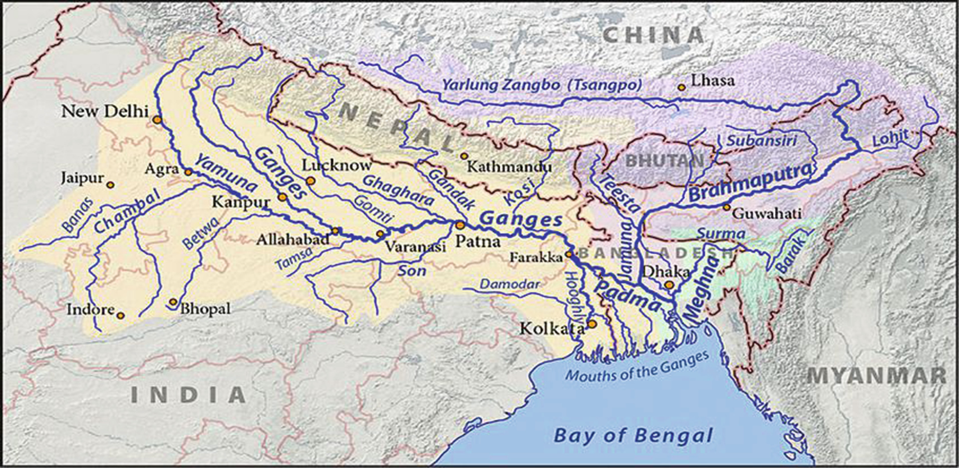
Shared by Bangladesh, Bhutan, China, India, and Nepal, the GBM Basin is vast and home to almost 10 percent of the world population. How successfully these countries manage their shared waters is critical to the region’s future, as the interconnectedness of the basin means that any action taken by one country affects its neighbors. The basin’s three major river systems collect rainfall in an area of 1.6 million square kilometers. As relevant maps indicate, both the Brahmaputra and the glaciers that feed the headwaters of the Ganga originate in China, then flow through India to join the Meghna in Bangladesh, and finally empty into the Bay of Bengal. Fed by many tributaries, these three rivers carry enormous amounts of water and hold great social, economic, and political significance. India and Bangladesh share all three river basins, and China shares two (the Ganga and the Brahmaputra), while Nepal and Bhutan are part of only one basin each (the Ganga and the Brahmaputra, respectively). Each river has distinguishing traits and passes through different terrain, but the wider basin is interconnected.
The GBM Basin is plagued by both current and latent, manmade and natural problems. The main challenges are constant flooding and rampant dam building that can affect water quality and quantity in downstream countries. The water supply is a long-term concern. While overall water availability in the basin is unlikely to drastically change soon, growing demand, dam activity, diversion, decreasing water quality, the drying up of certain tributaries, and the unpredictable effects of the climate will eventually strain the water supply if policy changes are not made. The aforementioned 2016 report by the UN Environment Program and a few partner organizations judged the GBM to be the world’s most vulnerable delta based on fifteen key indicators including water quantity, water quality, governance, socioeconomic vulnerability, and ecological impact.
Despite these looming concerns, the water management policies of adjacent countries are largely unintegrated. The basin needs to be examined as one unit and not as separate rivers within a single nation’s boundaries. The bilateral agreements most prevalent in the region often can deepen problems and frustrate the search for solutions, as they do not consider the effects for other countries that might share or be dependent on a given river or body of water. This shortcoming has led to further mistrust and unilateral decisionmaking. On the issue of dams, for example, without open dialogue and transparency, policymakers and the public typically assume that the structures are always harmful, which limits constructive debate and cooperation between countries.
CHINA’S QUEST FOR HYDRO-FUELED SUPREMACY
Water has become a strategic concern for China, a key stakeholder in South Asian water relations and in the GBM Basin. The glaciers that feed into the Ganga lie in China, and the country has sixteen major rivers that supply water to nearly 3 billion people across Asia. The Brahmaputra River, known as the Yarlung Tsangpo in China, is one such lifeline for the region. Rampant development over the last three decades has placed severe stress on China’s domestic water resources. The country’s growing reliance on water supplies shared with neighbors may run counter to its avowed diplomatic efforts to foster peace and economic opportunities for itself in its neighborhood and to present a positive international image.
China has designed its domestic water policy to suit its ambitious development needs, especially in its central and southern provinces. China essentially has an ambitious water resource management strategy designed to ensure energy and food security. In its Twelfth Five-Year Plan (which was released in 2011), the Chinese government described water quality and availability as obstacles to greater development. This problem is quite pressing because most of the country’s water lies in its southern and eastern provinces, while more populated regions located farther north are quite arid. All told, eleven of China’s thirty-three subnational “administrative units” suffer from water scarcity, and more than 28,000 waterways have vanished due to overexploitation and pollution.1
The use of shared water resources factors prominently in China’s development plans. The country has two long-term projects on the anvil: the South-North Water Diversion Project (SNWDP) and additional dam building to generate hydropower.2 Chinese officials and some of China’s southern neighbors have voiced misgivings about the SNWDP, which aims to divert water from resource-rich regions of China to predominantly northern, water-scarce regions. Some sections of the project have already begun transferring water, and hundreds of thousands of people have been relocated. Admittedly, these projects’ ecological impact is not yet fully understood. That said, any diversion of water is likely to affect downstream South and Southeast Asian countries. The western segment of the SNWDP, which will presumably draw water from the Yarlung Tsangpo, has been especially contentious and raised concerns in India and Bangladesh.
Beijing historically has been reluctant to engage in meaningful basin-wide water cooperation and acts very differently depending on which river basins and which neighbors are involved. Like a handful of other countries (including India), China refused to sign the 1997 UN Watercourses Convention, which informs relevant water policy, law, and international agreements around the world. Beijing has, however, notionally adopted basin-specific agreements and initiated diplomatic measures with certain neighbors based on its national interest and highly valued diplomatic relationships. To the north, for instance, China shares rivers with Mongolia, North Korea, and Russia. Beijing has more bilateral treaties with these countries than any others and typically makes decisions collectively with them.
This approach is vastly different from the way China treats countries to the northwest, south, and southeast. While Beijing is a signatory to several bilateral water agreements, these pacts are often nonbinding memorandums of understanding (MOUs) regarding the selling of hydrological data, joint research initiatives, navigation, management of river islands, and other issues. One important set of examples is the dam-building activities and massive hydroelectric projects that have affected the flow of water and the ecology of the Mekong River. China denounced the Mekong River Commission (MRC), an intergovernmental organization established in 1995 by Cambodia, Laos, Thailand, and Vietnam to jointly manage the shared Lower Mekong River. Yet Beijing established the Lancang-Mekong Cooperation in 2014 to coordinate subregional initiatives and advance connectivity by means of Chinese-funded infrastructure projects in the region through the Belt and Road Initiative. While this change might indicate a Chinese shift toward a preference for multilateral water cooperation, this effort is closely tied to Beijing’s overall geopolitical goals, and does not necessarily mean that it will translate to all other shared basins.
Although some countries have achieved positive results with China over shared water resources, Beijing is unlikely to participate in basin-wide cooperation that it has not initiated or does not control. China’s development goals limit its room for maneuvering. Any dam building or water diversion on the Tibetan Plateau or along the Yarlung Tsangpo will affect not only India but Nepal and Bangladesh as well. Both Dhaka and Kathmandu feature prominently in Beijing’s overall regional ambitions, which any conflict over water could complicate. At times, China has not been above using dam building or the withholding of key hydrological data as coercive tactics or political tools, and Beijing could resort to both strategies in the GBM Basin if necessary. Countries along the GBM Basin therefore need to formulate innovative policies for effective collective action that not only initiate discussions but keep participating countries engaged.
INDIA’S WATER DIPLOMACY
India has a stake in protecting and effectively managing the rivers of the GBM Basin with an eye toward the future. As both a downstream country (relative to China and Nepal) and an upstream country (relative to Bangladesh), India is in a unique position. So far, however, India has shown a preference for short-term bilateral treaties largely aimed at preventing conflict. Further, certain Indian domestic projects launched to manage its waters have caused tensions with neighboring countries and have raised ecological concerns. Given its own growing water needs, as well as its concerns about China, India would greatly benefit from engaging more with the other countries that share the GBM Basin.
For India, agriculture (especially in the country’s northern and northwestern belt) and development are at the heart of current water policy. Individual Indian states have significant influence over transboundary water agreements, an arrangement that sometimes impedes the policymaking process. India’s key concerns include outdated water infrastructure (such as leaky pipes), inefficient water usage, pollution, depleting groundwater, and a scarcity of potable water. To counter some of these issues, India has devised its own water transfer endeavor, the National River Linking Project, which aims to divert waters from certain Himalayan rivers by linking them with tributaries in northern India and by interlinking other rivers in peninsular India. This ambitious project began with one river in Madhya Pradesh in 2014. The project’s Himalayan component will depend on the waters of the Ganga and Brahmaputra Rivers.
Given the complexity of assessing the state of waterways, more information is needed to discern precisely how Chinese water diversion efforts might affect India and other downstream countries. In India’s view, any reduction in the flow of the Yarlung Tsangpo due to Chinese dam building or the SNWDP would likely affect development plans in India’s northeast states as well as the National River Linking Project and cause further tensions between the two countries. Beyond their impact on the water supply, Chinese water-diversion projects may have other negative ecological effects on waterways, such as reducing biodiversity and causing possibly high, unpredictable fluctuations in the water level. It is worth noting that dam building and other water diversion activities can affect both quantitative water volume levels as well as factors related to water quality, such as the amount of sediment in the water and variations in the flow of a given waterway.
In quantitative terms, it is important to recall that waterways can derive water from both rainfall as well as glacial and snow melt. As far as the Yarlung Tsangpo (and farther downstream, the Brahmaputra River) is concerned, the water that accumulates in the Chinese segment of the river tends to come mainly from glaciers and snow melt, whereas the water added in Indian territory tends to come mainly from rainfall. One estimate states that more precipitation joins the river after the Yarlung Tsangpo turns south toward India at a spot known as the Great Bend; it is believed that India receives 70 percent of the rainfall over the GBM Basin.
This may lead some observers to assume that any dam activity in Chinese territory would not significantly affect water flow and availability in India or farther downstream in Bangladesh. Although such an assumption may sound plausible, experts do not have enough information to draw a conclusive verdict on the likely efforts of Chinese water diversion, partly because this assumption does not factor in qualitative changes to the waterway or the impact of water that enters the river through snow melt. For these and other reasons, a lack of concrete data about the river and variance in long-term estimates about its future hamper the ability of decisionmakers to craft informed policy in affected countries. Over the long term, it would be detrimental for the area’s growing populations and for the health of the river for governments to create plans and take action without additional detailed studies and hard data. This reality underscores the need for collective basin-wide studies.
Meanwhile, any water diversion in India as part of the National River Linking Project or rampant development plans for the country’s northeastern states are likely to cause issues further downstream for Bangladesh. This puts India in a difficult position. Bangladesh’s food and energy security is wholly dependent on the GBM Basin. Over the years, Dhaka has criticized New Delhi for its dam building and for being hypocritical about transboundary water issues involving China. However, despite the disagreements India and Bangladesh have had over shared rivers, they have also enjoyed some measure of success in implementing treaties. After decades of a sour relationship, both nations signed the 1996 Ganga Water Treaty, which addressed water sharing at the Farakka Barrage, a controversial barrage that India built in 1975 to divert water from the Ganga River system.
For its part, Nepal has consistently argued that it has been unable to develop its hydropower potential because India does not want to jeopardize its water supply, a claim India denies. India can work with Nepal on hydropower to enhance trust and facilitate further cooperation. Past agreements between the two countries have prevented Nepal from exercising greater control over the waters that flow through its territory. India should revise these pacts to be more collaborative and to make the distribution and use of shared waters more equal and equitable. In 2013, Bangladesh, Bhutan, India, and Nepal set up the Water Resources Management Joint Working Group (a forum for subregional cooperation) to explore collaboration on hydropower development, trading of power, and grid connectivity. While the establishment of this platform might indicate greater Indian willingness to consider institutionalized multilateral cooperation, the exclusion of China is significant. The platform’s success is likely to remain limited.
New Delhi needs to reconsider its reactionary policy over shared transboundary rivers in the GBM Basin and be more consistent in its behavior toward downstream neighbors like Bangladesh and in its expectations of Beijing. To preempt China, India should move away from the outdated and narrow concept of prior-use rights in its dealings with Bangladesh. Prior use rights mean that any party that is first to use a quantity of water from a water source for what is termed beneficial use—agricultural, industrial, or household purposes—has the right to continue to use that quantity of water for that purpose indefinitely. This tactic is unlikely to work on China, and it could possibly further weaken New Delhi’s relationship with Dhaka to not recognize legitimate Bangladeshi protests. It is important for India to make common cause with Bangladesh and other basin countries as equal partners so as to collectively initiate dialogue with China.
NEXT STEPS FOR BASIN-WIDE COOPERATION
A basin-wide mechanism, designed to jointly manage rivers or regularly exchange information on water quantity and quality, could help counter many problems. Broadly speaking, basin-wide integrated management initiatives are often complicated by geopolitical concerns, member countries’ differing domestic policies, environmental changes, and growing demand for water usage. While such cooperation is difficult, many successful efforts around the world offer lessons for the GBM Basin. Though China might prove to be a difficult partner in such endeavors, Bangladesh, Bhutan, India, and Nepal share an interest in collectively pushing for incrementally greater basin-wide cooperation if these countries are to ensure sustained food, energy, health, and environmental security into the future.
There are many basin organizations in Asia and elsewhere—with varying agreements, treaties, and systems in place—that have moved from a state of conflict to cooperation. These experiences demonstrate that some measure of political will in favor of open dialogue and cooperation on shared waters is possible. The MRC, for example, provides lessons on data management. The commission has conducted extensive data collection along the basin to improve future mapping and forecasting in ways that support core MRC functions and member states. Similarly, the Senegal River Basin in West Africa has helped formulate best practices in joint dam building and hydropower generation; for this basin, collective ownership and responsibility have become the cornerstones of sustained, integrated water management, a sign of progress that has further helped build trust and accommodate open dialogue.
Moreover, there is reason to hope that, under certain conditions, cooperation can begin in certain areas and later expand. The Southern African Development Community, for instance, started as an intergovernmental organization for regional economic development before eventually expanding to cover the joint management of shared waters and other policy areas. Other important case studies include China’s recent Lancang-Mekong Cooperation platform and Kazakhstan’s sustained negotiations to desecuritize transboundary water disputes with China. In the latter instance, water is no longer viewed only in security terms but is seen as an important aspect of larger policy concerns and efforts to foster cooperation; this conceptual shift culminated in the 2011 China-Kazakhstan Friendship Joint Water Diversion Project.
While an integrated, basin-wide multilateral organization will be difficult to create, countries in the GBM Basin should start with smaller, simpler objectives such as joint forecasting or joint hydropower generation that can later cover more complicated issues like water sharing and consumption. Existing agreements and efforts to cultivate trust and cooperation offer a foundation to build on. For example, subregional cooperation on hydropower generation between Bangladesh, Bhutan, India, and Nepal could eventually be strengthened and expanded into a more comprehensive network that includes China. Another potential area of cooperation is navigation, especially for landlocked countries like Bhutan and Nepal and for India’s northeastern states. Opening navigation routes and bridging the distances between landlocked regions and the sea would benefit these economies, create new opportunities for trade and tourism, and enhance connectivity to the Bay of Bengal. Cooperation on other multilateral fronts, such as the Bay of Bengal Initiative for Multi-Sectoral Technical and Economic Cooperation, also provide avenues for smaller nations to enhance dialogue and diplomacy in innovative ways. Nepal can be a vibrant economic bridge between China and India by using geography to its advantage, a strategythat Nepalese Prime Minister K.P. Sharma Oli seems to be adopting.
Some limited forms of cooperation are already taking place. China currently shares flood forecasting data with India and Bangladesh during monsoon season, though Beijing briefly stopped this practice in 2017 with India purportedly due to the Doklam border standoff and India’s boycott of the BRI. It is necessary to share such knowledge more frequently, include other countries, and create mechanisms that attempt to isolate such endeavors from wider political tensions and the whims of government officials. In addition, India can engage China on issues that are not as politically sensitive, such as improving water quality or agricultural water usage. Even climate change could prompt greater coordination. The glaciers on the Tibetan Plateau that feed into the rivers of the GBM Basin are in danger of melting due to rising temperatures. Yet reliable estimates of this melting and shifting are unsystematic, and long-term data and projections are sparse. China and India have institutional arrangements for data sharing to address climate change, and joint research on glaciers can be made a part of such initiatives. By studying relevant best practices from around the world and adapting them to the region, by adopting a strategy that views China as part of the solution, and by using existing collaborative mechanisms, the countries of the GBM Basin can enhance transboundary water cooperation in ways that will have long-term benefits for the region.
CONCLUSION
The need for and the potential benefits of cooperation are clear. Yet unless countries in the GBM Basin first develop policies that balance the differences between their water management efforts and water needs, any agreement will be of limited effectiveness, especially attempts to create a workable multilateral institution. Collaboration requires political will and cannot simply be based on new institutions. Evidence indicates that cooperation on shared water has increased over time, even in the GBM Basin, through the few existing agreements and MOUs. Obviously (and undeniably), more needs to be done. The fact that governments in other contentious regions have managed to enhance cooperation over shared waters makes the ongoing failure to do more in the GBM Basin all the more lamentable. Growing populations and demand for water, changes in the climate and environment of the basin, and ineffective water management all necessitate a far deeper understanding of the basin, better data sharing practices, and increased collaboration.
Basin-wide cooperation will not be easy. Several obstacles plague transboundary governance in the region—including bureaucratic inertia, a lack of political will, China’s recalcitrance and ambitions, India’s domestic political issues, and the inability of the basin’s smaller nations to effectively exert pressure. Yet China’s recent actions toward other neighbors indicate that changes might be possible given the right incentives. A discussion on trade and China’s contentious Belt and Road Initiative between all riparian states, open dialogue on border concerns, or even considerations of international image on other global political issues could be potential starting points for such an overture. Success is not guaranteed, and enormous challenges could still derail any cooperative efforts, but the consequences of complacency would be negative for the entire region and beyond. India needs to be more proactive and push for a comprehensive, basin-wide mechanism between the five affected countries, work with them to find suitable areas for dialogue, and keep China, in particular, engaged through diplomacy.
Ambika Vishwanath is a geopolitical consultant and global strategy adviser with a special focus on the nexus between foreign policy, water security, and diplomacy. She is a nonresident fellow with the Agora Strategy Institute in Germany and tweets @theidlethinker.
NOTES
1 China has twenty-two provinces, four independently administered municipalities, five autonomous regions, and two special administrative regions (Hong Kong and Macau). See Denis C. Twitchett et al, “China,” Encyclopedia Britannica, https://www.britannica.com/place/China.
2 Author’s conversations with Chinese experts (some over email and some in person), New Delhi, Summer 2017.
No comments:
Post a Comment