BY Alexandra Coultrup
Both military and civilian entities make regular use of satellite-enabled Global Positioning System (GPS) and communication technology via signals transmitted over various radio frequencies. However, reliable transmission of this information can be disrupted through electronic counterspace attacks, including jamming and spoofing.
Counterspace Weapons 101
For a brief description of the four categories of counterspace weapons used in this report, read “Counterspace Weapons 101,” from the CSIS Aerospace 101 article series.
Since late 2017, GPS users in northern Scandinavia have experienced signal disruptions in conjunction with military exercises in the region. The interactive map above highlights three distinct military exercises during which GPS signal loss was recorded: Russia’s Zapad-2017 exercise, the North American Treaty Organization’s (NATO) Trident Juncture exercise, and the United Kingdom’s Clockwork exercise.
In some cases, the Civil Aviation Authority of Norway was made aware of GPS disruptions in advance and could include them in their Notice to Airmen (NOTAM) alerts. Other periods of signal loss were unscheduled.1Though many civilian and passenger planes have backup instruments for navigation, surprise interruptions to GPS service can still have dangerous results for airborne and ground personnel alike. Without GPS, aircraft pilots and ship captains can lose the ability to verify their precise position, especially if it is not obvious to them that service has lapsed.2
Electronic attacks are not always precise. During an attack, jamming signals radiate outward from a central source, and can affect any device that is within both range and line of sight. Often, only high-profile jamming occurrences affecting a larger entity—such as governments, large commercial airlines, or media organizations—are reported in the media or by government agencies. Therefore, discrete points presented on the maps do not necessarily represent the full scope signal loss of jamming-affected areas.
Methodology
In this database, “signal loss” is defined as instances in which users were unable to access normally-available satellite-enabled data, which can include GPS and communication services.
This database was constructed using publicly available reports from regional media outlets and federal authorities. In most cases, reports of signal loss included both a specified start and end date, which together define the period of illumination on the interactive map above. In instances where reports of signal loss included only a start date, the illumination graphic on the interactive above lasts for three days. This length of time is comparable to other periods of signal loss in the region.
The three scenarios included in this database do not include all instances of signal loss in the Arctic Circle region since September 2017, but rather those that correspond to the three military activities described below. These selected instances make up a majority of reported jamming occurrences in the area during the time frame presented.
Zapad-2017
From September 14 to 20, 2017, Russia and Belarus conducted a joint military exercise called Zapad—meaning “West” in Russian—across the northwestern region of Russia, from Belarus to the Barents Sea.
From September 7 to 20, 2017, commercial pilots of Widerøe—one of Norway’s largest regional airlines—reported GPS signal losses while flying in airspace ranging from the northernmost region of Norway to towns as far as 600 km (372 miles) away on the country’s western coast.3 This northern region, called Finnmark, shares a border with Russia and is home to Kirkenes, an airport that supported almost 30,000 passengers that month.4
These reports of signal loss coincided with Zapad-2017 activities at the Pechenga military base in nearby Murmansk Oblast.5 Thousands of military units—13,000 according to Russia and 100,000 according to NATO—engaged in the exercises near the country’s northeastern borders. Zapad-2017 placed an emphasis on the use of electronic warfare, including jamming communication signals used by Russian troops to simulate operations in a compromised environment.6 It is possible that these jamming signals are what affected both the Kirkenes airport and other nearby areas.
On September 15, 2017, the Norwegian National Communications Authority conducted an investigation by helicopter and concluded that the signal disruptions originated from the east, near Russia.7 Investigators on board flew a route from Kirkenes eastward and measured that the jamming signals grew stronger as they travelled further east toward the border, where Norway’s Finnmark County sits adjacent Russia’s Murmansk Oblast.8
Not every instance of jamming can be reported, either in location or in date. Individual citizens may not choose to report signal loss to official channels, and users filing official reports may not notice the exact start date of the issue, or understand the extent of its affect. The reports on record suggest widespread interference with GPS signal over the region. For example, loss of GPS signal at both Kirkenes and Alta on the same day may indicate the region between these two locations was affected as well.
Trident Juncture
The Trident Juncture was a large-scale NATO military exercise hosted in Norway in October and November 2018. Military personnel from 31 different countries came together for the exercise: all 29 NATO members, plus Finland and Sweden.9 The Trident Juncture exercises incorporated air, land, and maritime operations both as a display of strength to ensure security for border nations.10
Avinor—Norway’s state-owned civilian airport operations company—receives reports from the Norwegian military when GPS signal loss is discovered in conjunction with military activity and is authorized to issue NOTAM warnings to civilian pilots. One such warning was filed for the airspace surrounding Kirkenes for October 25 to November 2, 2018. The NOTAM advised that irregular GPS behavior had been reported within the Kirkenes airport’s terminal area. During the two-week exercise, Wenche Olsen, the director of Norway’s Civil Aviation Authority, stated that “there are reasons to believe it [the reported jamming] could be related to military exercises outside Norway’s borders.”11 The jamming caused several instances of significant interference. For example, Mehamn civilian airport also suffered from GPS signal loss from October 24 to November 7, 2018, and was forced to use alternative navigation equipment, which was ground-based and not functioning properly. As a result, an air ambulance intending to land at Mehamn had to divert away from its intended airport.12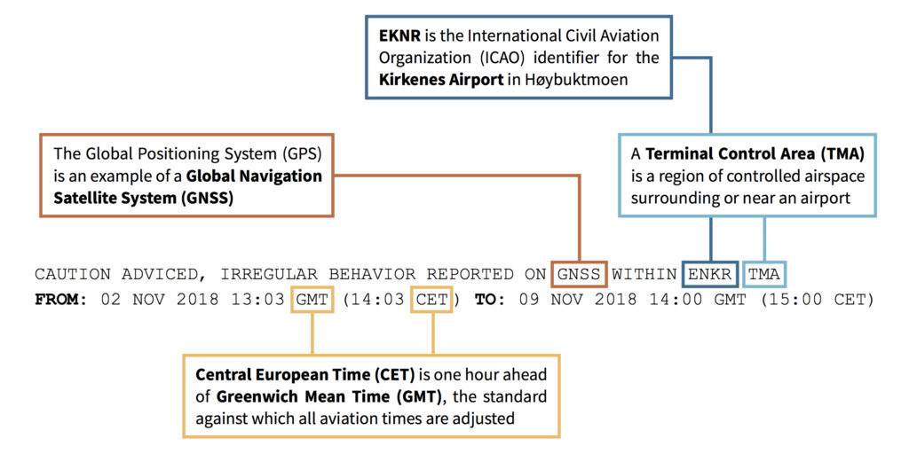 A Notice to Airmen (NOTAM) alert was issued in November 2018 due to GPS signal loss from 2:03 PM local time on November 2 until 3:00 PM local time on November 7 near Kirkenes Airport in northeast Norway. Source: U.S. Federal Aviation Administration
A Notice to Airmen (NOTAM) alert was issued in November 2018 due to GPS signal loss from 2:03 PM local time on November 2 until 3:00 PM local time on November 7 near Kirkenes Airport in northeast Norway. Source: U.S. Federal Aviation Administration
The Trident Juncture exercises were officially scheduled to run from October 25 to November 7, 2018. However, civilian operators in Norway reported signal loss as early as October 16. The same day, Russian forces were operating at Pechenga, outside of a formally announced military exercise.13 NATO Secretary General Jens Stoltenberg condemned the jamming as dangerous and irresponsible, stating: “we see that cyber, electronic warfare, electronic means are used more and more frequent [sic] in different operations, and therefore we take all these issues very seriously.”14
During Trident Juncture, NATO forces operated extensively out of Norway’s Bodø Air Base, located on the country’s west coast. The base supported aircraft including Mirage 2000s from France, F-16s from Greece and Turkey, CC-150 tankers from Spain and Canada throughout the duration of the exercises.15
The Russian government stated its opposition to the NATO exercises, commenting that such displays erode confidence and stability in the region. The Russian navy carried out “sharpshooting” and missile tests off the Norwegian coast from November 6 to 9, 2018, in areas overlapping with the planned exercises of Trident Juncture. Norwegian Prime Minister Erna Solberg said these tests were to be expected from Russia, who she said “wants to show muscles.”16
Airports—including those at Kirkenes, Lyngen, Mehamn, and Alta—reported GPS loss from October 24 to November 7, 2018. In some cases, signal loss was experienced at altitude, but not on the ground. Because jamming signals require line-of-sight access to successfully jam their targets, the source of the interference may have been a great distance away and partially blocked by the curvature of the Earth. Lyngen, the westernmost of the cities affected in this timeframe, sits 381 km (237 mi) from Norway’s border with Russia. However, civilian users in Sør-Varanger, the municipality containing Kirkenes, also reported that mapping services on their phones provided erroneous data during this time, with location errors as far off as one kilometer.17
Clockwork
In January and February 2019 the United Kingdom conducted its annual Clockwork military exercise. Clockwork 2019 was based out of at Bardufoss air station in Tromsø in order to test the endurance of both human and aircraft performance in extreme temperatures.18 Helicopters dedicated to the Clockwork exercise first arrived in the Arctic Circle region on January 7, 2019.19
GPS signal loss was reported along the Russia-Norway border on January 9 and 10, 2019.20In Kirkenes, a construction company reported that the signal loss interfered with its day-to-day operations, because they rely on the precision data satellite service can provide. The company reported that the loss of GPS service threatened their ability to safely excavate around infrastructure such as water pipes, which could lead to loss of time and money.21
No comments:
Post a Comment