April 15, 2014
I. INTRODUCTION
The Geospatial Technologies and Human Rights Project of the American Association for the Advancement of Science (AAAS) has undertaken analysis of the crisis between Ukraine and Russia in Crimea using high-resolution satellite imagery. This analysis forms part of a broader study aimed at investigating cross-border conflicts to identify early warning signs to aid in future conflict prevention efforts. High-resolution satellite imagery provides a particularly useful tool for monitoring and quantifying key metrics in border conflicts, such as troop deployments and the movement of military vehicles. By documenting these indicators, geospatial analysis can provide clarity in circumstances where other data are ambiguous, incomplete, disguised, or concealed.
The situation in Crimea fits this description, and has been defined by conflicting narratives regarding events on the ground. Following months of protest in the Ukrainian capital of Kiev, which culminated in the ouster of former president Viktor Yanukovich, pro-Russian protests in the southern Ukrainian region of Crimea emerged in early 2014. These quickly escalated on 27-28 February, when uniformed armed troops lacking identifying insignia seized Simferopol International Airport and a military airfield in Sevastopol.1 Russian government officials denied involvement in these events. At the same time, the vehicles and military hardware associated with the unidentified armed groups led many observers to suspect that they were Russian troops acting as part of a coordinated military campaign. According to the U.S. Department of State:
“Strong evidence suggests that members of Russian security services are at the heart of the highly organized anti-Ukraine forces in Crimea. While these units wear uniforms without insignia, they drive vehicles with Russian military license plates and freely identify themselves as Russian security forces when asked by the international media and the Ukrainian military. Moreover, these individuals are armed with weapons not generally available to civilians.”
-U.S. Department of State, 5 March 2014 2
Due to the volatile situation and the high level of uncertainty related to events on the ground, AAAS is examining multiple locations within Crimea using high-resolution satellite images obtained in 2013 and 2014. The subject of this report is the port city of Sevastopol (Figure 1), and focuses on the period from 10-18 March 2014. Sevastopol is the base of Russia’s Black Sea Fleet. Because of the concentration of Russian military equipment and personnel in the city, reports alleging Russian movement outside its own military facilities, and claims that many Ukrainian military sites were under siege, it was determined that an in-depth analysis of the area was warranted. The dual objectives of this investigation are to clarify the situation on the ground and to identify features that could serve as warning signs should the crisis escalate into a broader armed conflict.3
Figure 1: Sevastopol

II. DATA AND METHODS
Using information on locations of Russian military bases4 as well as news media reports, AAAS acquired multiple images of the area of Sevastopol (Table 1). The area was imaged frequently in the days following the escalation of events in Crimea.
Table 2: Imagery acquired*
Date Sensor Image ID18 March 2014World View 2103001002E56EF0012 March 2014**QuickBird-2101001001272070010 March 2014QuickBird-21010010012706D005 February 2014QuickBird-2101001001256FC0007 July 2013WorldView-11020010024EBFE00
*All imagery acquired via DigitalGlobe, NextView license
**Image does not cover full extent of study area
Analysis of Sevastopol focused on the documentation of Russian military bases and port facilities within and near the city (Figure 2). Analysis of the imagery resulted in a number of observations that can be grouped into two broad categories: those involving land-based forces (e.g., vehicle and troop deployments); and those associated with naval activity, such as ship movements.5
Figure 2: Locations of figures in this report

III. RESULTS
Land Forces
Russia operates numerous shore-based military facilities in and around Sevastopol. Analysis of these facilities revealed hundreds of military vehicles parked in depots throughout the area. In itself, the presence of these vehicles is not suggestive of any build-up of forces or offensive military preparations - the vast majority of the vehicles were present prior to the crisis and remained stationary throughout the duration of the study period. In some instances, however, changes in the distribution of vehicles were noted that could be explained by engagement in operations outside the confines of their bases, as shown in Figure 3. Particularly notable is the absence of nine BTR-80/82 armored personnel carriers, which the Black Sea Fleet’s marine garrison is known to possess.6 Caution is necessary when advancing this interpretation, however, as other explanations for vehicle movements are also plausible, such as routine maintenance. If the movements of these vehicles were related to military activity, one possible destination for them was identified southeast of Sevastopol, where by 10 March a roadblock was observed to have been erected across both lanes of an overpass of the N-19 highway leading into and out of the city (Figure 4).
Figure 3: Activity of combat and logistics vehicles


Between July 2013 and March 2014, nine vehicles whose dimensions and camouflage patterns match those of Russian BTR-80/82 armored personnel carriers (arrows) were no longer visible in the yard of the 810th Separate Marine Brigade’s vehicle depot at Cossack Bay (top). During the period from 5 February to 10 March 2014 (bottom) a number of heavy trucks (arrows) have arrived in the courtyard of the Russian Naval Barracks at Pivdenna Bay. Coordinates (top): 44.56N, 33.41E, (bottom): 44.61N, 33.54E. Image ©2014, DigitalGlobe, NextView License | Analysis AAAS.
Figure 4: Roadblock on N-19 Highway


The N-19 highway, unobstructed in on 5 February 2014, is one of the principal roads leading to and from Sevastopol, and was the site of a roadblock that was erected prior to 10 March 2014. By placing the checkpoint on an overpass, those controlling it are able to prevent vehicles from circumventing the barrier. Coordinates: 44.53N, 33.62E. Image ©2014, DigitalGlobe, NextView License | Analysis AAAS.
Naval Forces
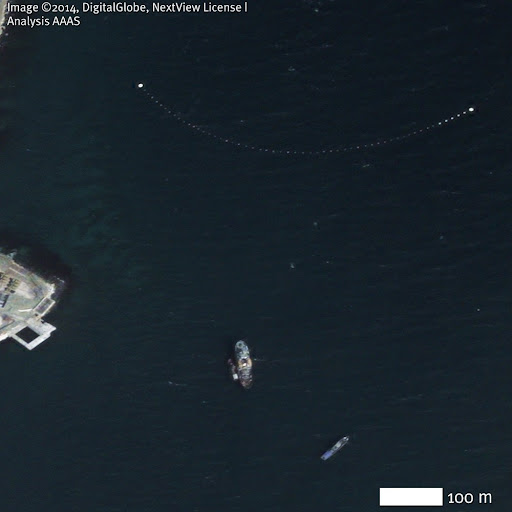
As both the base of operations for Russia’s Black Sea Fleet and a major commercial port, Sevastopol is a large regional center for maritime traffic. Similar to the trends observed on land, observations of vessels in Sevastopol’s many harbors and bays revealed trends consistent with a tightening of military control of the seas. At the entrance to Sevastopol Bay, for instance, the gap between the two breakwaters that separate the port of Sevastopol from the Black Sea itself was observed to be open to navigation on 5 February 2014. By 10 March 2014, however, and continuing through 18 March, the opening is controlled by a tugboat towing a floating chain or net attached to a new mooring buoy on the south side of the channel (Figure 5). The dimensions and superstructure configuration of this vessel are both consistent with those of an Okhtenskiy class seagoing tug, of which the Black Sea Fleet possesses seven, and whose color schemes match with that of the tug in question (Figure 6). During the same period, a similar obstacle was observed to have been erected at the entrance to Striletska Bay, located 2.5 kilometers to the west. Despite these controls, however, vessels of the Russian Navy were observed to have departed from their moorings and exited Sevastopol Bay; their current locations are unknown (Figure 7). Noteworthy among this military traffic are two Ropucha class landing ships, each of which is capable of transporting up to 24 armored personnel carriers of the type that are no longer visible at the Cossack Bay Marine Garrison, and a Kashtan class mooring buoy tender that would be ideal for anchoring the ends of additional barricades of the type shown in Figure 5.7 Taken in sum, these observations strongly suggest that it is the Russian Navy that controls the entrances to the harbors.
Figure 5: Obstructions to navigation at the entrance to Sevastopol and Striletska Bays
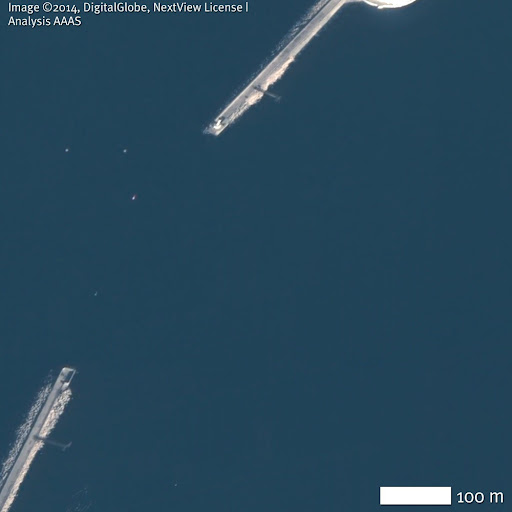


Navigation into Sevastopol and Striletska Bays, open on 5 February 2014, has been restricted by the placement of nets or booms by March 12, 2014. Coordinates: (top, Sevastopol Bay): 44.62N, 33.51E, (bottom, Striletska Bay): 44.61N, 33.47E. Image ©2014, DigitalGlobe, NextView License | Analysis AAAS.
Figure 6: Detail of tug and mooring buoy

The dimensions, superstructure, and color scheme of the tug which controls access to Sevastopol Bay are very similar to Russia’s Okhtenskiy class of seagoing tugs, such as MB-173 (inset). Coordinates: 44.62N, 33.51E. Inset photo by A. Brichevsky, Black Sea Fleet Information Resource. Satellite image ©2014, DigitalGlobe, NextView License | Analysis AAAS.
Figure 7: Naval movements in Sevastopol Bay
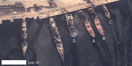

Despite the barriers to navigation described above, in Sevastopol Bay, two Ropucha class landing ships (A, B), a Nanuchka class missile corvette (C), and a Kashtan class mooring buoy tender (D) departed the naval base between 12 March (top) and 18 March (bottom), while a third Ropucha class landing ship (E) arrived. Coordinates: 44.62N, 33.56E. Image ©2014, DigitalGlobe, NextView License | Analysis AAAS.
IV. CONCLUSION
Analysis of the port city of Sevastopol, which houses the Russian Black Sea Fleet, has revealed a number of observations that can be considered warning signs of a potential armed conflict. These include the movement of combat and logistics vehicles, the construction of roadblocks, and the establishment of a maritime blockade of strategic ports and harbors. Particularly in the case of maritime actions, these observations suggest a level of coordination and organization consistent with the interpretation that the armed groups which seized control of Crimea in February-March 2014 were not solely “spontaneous self-defense militias”. The apparent use of Russian naval vessels to blockade the port of Sevastopol strongly suggests that such actions are at the very least supported by the Russian military. Of course, alternate interpretations of the imagery are possible, particularly with respect to the deployment and disposition of land-based forces. Nevertheless, when viewed in light of reports alleging the presence of Russian troops on the ground alongside irregular units, this analysis lends credibility to the involvement of Russian military forces in the takeover of Sevastopol.
Upcoming reports in this series will focus on other Russian and Ukrainian military bases throughout Crimea to determine whether high-resolution satellite imagery can provide further clarification of this evolving situation, and identify further warning signs of a possible future armed conflict between these two countries.
For a PDF version of this case study, click here.
1. For a timeline of events see: BBC News; Al-Jazeera.
4. Obtained via globalsecurity.org and other online sources
5. Although both a military airfield and a helicopter facility are present in Sevastopol, AAAS noted no aircraft activity in the city during the study period.
6. “Russia Tests New Amphibious Armored Vehicle,” RIA Novosti, 11/04/2013;Photo by A. Brichevsky
No comments:
Post a Comment