By Col Harjeet Singh
There appears to be a growing perception of Indian wrongdoing on water in Pakistani minds. While India–Pakistan relations are not on even keel, another canard can only add to the already strained situation. That the issue needs to be understood objectively and shorn of the hype, on both sides of the border, is self-evident.
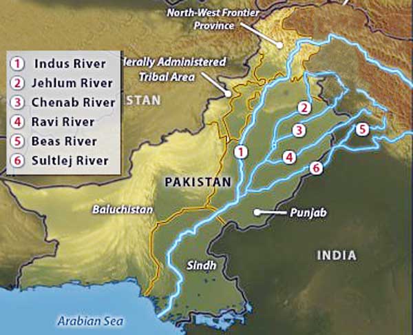
in 1960, with the signing of the Indus Waters Treaty wherein the three western rivers Indus, Jhelum and Chenab were awarded to Pakistan and the three eastern rivers Ravi, Beas and Sutlej to India. This division provided Pakistan with 56 percent of the catchment area and India with 31 percent.
It is an inexorable fact that there is a sense of an imminent (or already present) water crisis in both countries. The per capita availability of water has declined; groundwater is under stress through over-exploitation; river flows are diminishing, and some rivers are so polluted as to be no more than sewers; and water supply in cities is intermittent and unreliable. However, the perception of a crisis and the recent voices in Pakistan towards attribution of that crisis to Indian wrongdoing is a new development that needs to be viewed with concern and saner voices need to come into play.
But first, let us retrace the problem in its historical context. For centuries, the Indus River Basin constituted a unified geography spread over almost 1.2 million square kilometres. The acrimony of partition of the subcontinent led to East Punjab stopping the flow of water to West Punjab, in 1948, stating absolute sovereignty. Flows were resumed when Pakistan paid India for administrative costs. The Inter-Dominion Accord of 1948 was a temporary agreement that required India to release sufficient water to Pakistan in return for annual payments. However, water continued to be a source of contention within the region.
The situation was finally resolved, in 1960, with the signing of the Indus Waters Treaty wherein the three western rivers Indus, Jhelum and Chenab were awarded to Pakistan and the three eastern rivers Ravi, Beas and Sutlej to India. This division provided Pakistan with 56 percent of the catchment area and India with 31 percent. The authors of the Treaty had hoped that the division of the Indus Water Basin would eventually lead to the unity of people in Pakistan and India. Sixty years later, they seem to be proved wrong. In fact, the concern over the distribution of the Indus catchment area raises the basic question whether short term divisive solutions can be sustained in the long run. Perhaps water would not have been a central issue had it been utilised efficiently over the last half century in both countries. Unfortunately, that has not been the case. Nevertheless, war over water is not strategically rational, hydrographically effective, nor economically viable.
The recent monsoon floods that have devastated Pakistan place it on the verge of a critical shortage of fresh water. The monsoon floods have obliterated countless canals, diversion weirs and huge swathes of cropland. And water scarcity is not only a worry for Pakistan’s population—it is unlikely that Pakistani food production will long keep pace with the growing population. A widespread water shortage in Pakistan would further destabilize the fractious country.
The River Indus and its tributaries are the main source of water supply in Pakistan. Dams and barrages have been built on the Indus and its tributaries to store water.
Physical Geography
Pakistan can be divided into five physiographic regions:
The Himalaya Mountains in the northwest on the border with India and China. The highest peak, K-2 (8,611 metres) is part of the Trans-Himalayan Range.
The Hindu Kush and the Western Mountains in the north on the border with Afghanistan. The Tirichmir (7,690 metres) is the highest peak in the Hindu Kush range.
The Potwar Plateau, just south of Islamabad. The elevation varies from 300 to 600 metres. South of the Potwar Plateau is the Salt Range.
The Indus Plain, stretching from the Salt Range to the Arabian Sea. This flat plain is largely made up of alluvium, over 300 metres deep, deposited by the Indus River and its tributaries.
The Balochistan Plateau in the southwest of the country, with an average altitude of about 600 metres. Dry hills run across the plateau from northeast to southwest. A large part of the northwest is desert.
The River Indus and its tributaries are the main source of water supply in Pakistan. Dams and barrages have been built on the Indus and its tributaries to store water. Large dams at Tarbela and Mangla are multipurpose projects storing water, irrigating lands and also generating hydro electricity. Small dams like those at Khanpur, Rawal and Hub supply water for agriculture, industrial and domestic use and act as a reservoir as well. Barrages supply water for irrigation as well as industrial and domestic use.
Irrigation is the man-made supply of water to the land to encourage vegetation. In Pakistan, 75 percent of the agricultural land is under irrigation. The major water sources in Pakistan are rain water, ground water and rivers. The irrigation system of Pakistan is the largest integrated network in the world. There are 3 major storage reservoirs, 19 barrages, 12 inter-river link canals, 45 independent irrigation canal commands and over 122,268 watercourses. Perhaps no other area in the world can claim so many major rivers flowing in close proximity of each other. In that sense Pakistan is unique.
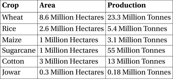
The total cultivable area in Pakistan was estimated at 29.9 million hectares in 1990, which is 37 percent of the total area, mainly concentrated in the Indus plain. In 1990, the total cultivated area was estimated at almost 16.6 million hectares, or 55 percent of the cultivable area, of which 16.1 million hectares consisted of annual crops and almost 0.5 million hectares consisted of permanent crops. See Table 1 for details.
 Table 1: Crop-wise Area under Cultivation and Production: 2006-2007 (Source: Ministry of Food, Agriculture & Livestock (Economic, Trade & Investment Wing), Agricultural Statistics of Pakistan, 2006-2007, Government of Pakistan)
The total population is 141 million (1995), of which 65 percent is rural. The average population density is 177 inhabitants per square kilometre, but the population is mainly concentrated in the Indus plain. The average annual population growth is estimated at about 3.2 percent. In 1992, agriculture accounted for 26 percent of the gross domestic product (GDP) and provided employment to 48 percent of the labour force. It supplies most of the country’s food, but is also the source of raw materials for major domestic industries, particularly for cotton products which account for 80 percent of export earnings.
Under the treaty, India is allowed to store 3.6 MAF of water of the western rivers, but it has not built any such facility so far, allowing unimpeded flows into Pakistan.
Pakistan has three hydrological units:
The Indus basin, covers more than 566,000 square kilometres (or 71 percent of the territory), comprising the whole of the provinces of the Punjab, Sindh, and Khyber-Pakhtunkhwa and the eastern part of Balochistan. The Indus River has two main tributaries, the Kabul on the right bank and the Panjnad on the left bank. The Panjnad is the resulting flow of five main rivers: the Jhelum and Chenab, known as the western rivers, and the Ravi, Beas and Sutlej known as the eastern rivers.
The Karan desert in the west of Balochistan (in the west of the country) covers 15 percent of the territory. The Mashkel and Marjen rivers are the principal source of water in the basin. The water is discharged in the Hamun-i-Mashkel lake, in the southwest at the border with Iran.
The arid Makran coast along the Arabian Sea covers 14 percent of the territory in its southwestern part (Balochistan province). The Hob, Porali, Hingol, and Dasht are the principal rivers of this coastal zone.
The Indus River, originating at 17,000 feet above sea level in Tibet, is 3,180 kilometres long and traverses past the Himalayas in Jammu and Kashmir through Pakistan before emptying into the Arabian Sea. The river has a total drainage area exceeding 1,165,000 square kilometres. The river’s estimated annual flow stands at around 207 cubic kilometres. The flow of the Indus fluctuates seasonally, with melting of Himalayan glaciers accounting for almost 90 percent of the water in the Upper Indus River Basin. Although most of the Indus Basin lies in a zone of deficient rainfall (< 10 inches annually), abundant flow is present during the monsoon season (July – September), which accounts for 51 percent of the annual flow. Nearly 10 percent of the rainfall is lost by evaporation and nearly 41 MAF is lost by seepage from unlined canals, which results in water logging, rendering the land useless for agriculture.
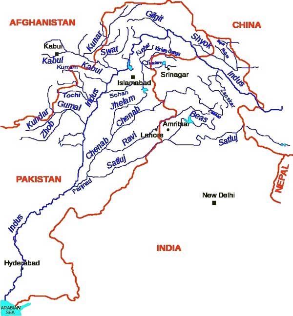 56 percent of the total drainage area of the Indus basin lies in Pakistan, and the remainder in China, Afghanistan, and India. Because of the importance of irrigation in the Indus plain, the water balance of the Indus basin has been carefully studied. The mean annual inflow into Pakistan through the western rivers (the Indus, including the Kabul tributary, Jhelum and Chenab) amounted to 170.27 cubic kilometres per year in 1995. The mean annual natural inflow into India through the eastern rivers (Ravi, Beas, and Sutlej) is estimated at 11.1 cubic kilometers per year, but this is reserved for India, according to the 1960 Indus Water Treaty.
As an upper riparian locked in a politically adversarial relationship with Pakistan, India had little or no incentive to look at the Indus basin as an integrated water system.
The Indus Water Treaty
The 4,000 year-old Indus civilization has its roots in irrigated agriculture. The abandoned creeks of the meandering river, inundated during the flood season, served as the irrigation channels of the ancient systems. The first controlled all-year irrigation began in 1859 with the completion of the Upper Bari Doab Canal emanating from the Madhopur head works on the Ravi River. The Sukkur barrage, completed in 1932, is the first modern hydraulic structure on the downstream Indus River.
Though inter-provincial disputes over water sharing existed in this region before 1947, the partition of the subcontinent introduced a further complexity. It was easy for Radcliffe to draw a line on a map and divide the land of British India but people and water were harder to partition. The mass migration and bloodshed it triggered is well-known but the rupture to the region’s hydrological system was just as traumatic. The rivers which irrigated the new nation of Pakistan had their origins in India. As an upper riparian locked in a politically adversarial relationship with Pakistan, India had little or no incentive to look at the Indus basin as an integrated water system. The early years of independence saw bitter disputes over the usage of the water. Geography and terrain meant that the Indus itself could not be harnessed on the Indian side but small-scale diversions on the tributaries generated considerable tension with Pakistan.
In 1952, the World Bank put forward a proposal for the equitable distribution of the water resources of the Indus Waters Basin. The proposal had three essential features:
The waters of the three western rivers – Indus, Jhelum and Chenab – to be allocated to Pakistan, and the waters of the three eastern rivers, Ravi, Beas and Sutlej – to India. The requirements of the areas within Pakistan, hitherto fed by the eastern rivers, would be met by waters to be transferred from the western rivers by means of a system of river link canals. It was estimated that some 14 million acre feet would be required, ultimately, to replace the water designated for use in India.
India would make a contribution of £ 62 million towards the cost of the replacement works.
During the construction phase, India would limit her withdrawals from the eastern rivers in proportion to Pakistan’s capacity to replace.
Pakistan has 3 large dams, 85 small dams, 19 barrages, 12 inter link canals, 45 canals and 0.7 million tube wells to meet its commercial, domestic and irrigational needs…
The Indus Waters Treaty (IWT) is regarded as one of the few successful settlements of a trans-boundary water basin conflict. It took eight years of negotiations before agreement was reached and was signed on 19 September 1960, with the World Bank’s mediation. The IWT partitioned the six rivers of the Indus basin on a crudely longitudinal basis. India was given exclusive use of the waters of the three eastern tributaries, Ravi, Beas and Sutlej, and the right to “non-consumptive” use of the western rivers, Indus, Jhelum and Chenab. India renounced its right to block or divert the flows of the ‘western’ rivers and agreed to confine itself to run-of-the-river hydroelectric projects and drawing of irrigation water for a specified acreage of farm land. This partitioning was irrational from an ecological standpoint and led to both sides incurring considerable expense to develop canal infrastructures drawing on “their” allocated rivers to compensate for the non-use of the other side’s rivers.
To compensate Pakistan for the loss of the water of the eastern rivers, six friendly countries and the World Bank together with India provided funds for the construction of replacement works in Pakistan. The World Bank and other international agencies provided $870 million to Pakistan and $200 million to India to defray infrastructure costs. A transition period till 31 March 1970 was allowed so that Pakistan could build its link canal system to divert water from its Western Rivers to Eastern Rivers. It was incumbent on both sides to avoid building any man made structure which could change the natural course of water; and both sides were responsible for maintaining the Indus basin by adopting the best practices available. India is also bound to inform Pakistan about the design of any work on the Western rivers. Under the treaty, India is allowed to store 3.6 MAF of water of the western rivers, but it has not built any such facility so far, allowing unimpeded flows into Pakistan.
The Indus Basin Irrigation System (IBIS)
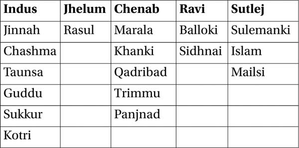
Pakistan linked its rivers through a canal-link system. Canals were taken out from the rivers, through dams and barrages. At the time of the partition of India barrages existed at Madhopur and Hussainiwala in India, while Pakistan had the Kalabagh, Sukkur, Trimmu, Baloki, Sulemanki and Islam barrages. No storage dam existed on either side. Today, Pakistan has 3 large dams, 85 small dams, 19 barrages, 12 inter link canals, 45 canals and 0.7 million tube wells to meet its commercial, domestic and irrigational needs – one of the largest canal irrigation systems in the world. The canal links constructed are given at Table 2.
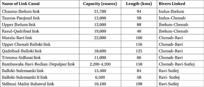
Table 2: River-link canals constructed by Pakistan
Most of the link canals are unlined. They were built at a cost of 400 crore rupees, with a total capacity of 140,000 cusecs per day, transferring 2.81 MAF of water. The length of the links is about 900 kilometres. The barrages constructed on the various rivers in Pakistan are given at Table 3.
 Table 3: River Barrages in Pakistan
The IBIS covers all the provinces in Pakistan. In 1993, irrigated areas in the IBIS were estimated at 13,972,500 hectares. In addition, in Khyber Pakhtunkhwa, about 7,800 hectares are irrigated through pump lifts which are maintained by the Provincial Irrigation Department. In northern parts of the province, irrigation is practiced by contour channels taking-off from locally available water sources i.e. streams or springs. Most of these schemes, which cover about 26,700 hectares, are owned and operated directly by the beneficiaries through traditional social organizations. In Balochistan, about 50,000 hectares are irrigated from about 800 underground channel tapping aquifers and from perennial springs. They are small group-operated schemes, with sizes ranging between 50 and 400 hectares. In addition, about 130,000 hectares of group-operated schemes are irrigated from infiltration galleries or small weirs in rivers, and about 130,000 hectares are irrigated by tube-wells and 10,000 hecatres from open wells.
Due to inadequate water availability in winter (storage capacity is too small) and at the beginning and end of summer, cropping intensity is exceptionally low.
Spate irrigation covers a total area of 1,402,448 hectares. In Pakistan, these areas are known as Rod Kohi in Khyber Pakhtunkhwa and Punjab, and Bandat in Balochistan, which is basically flood irrigation. Wherever possible, the runoff is harnessed for irrigation by weirs or temporary diversion structures. Farmers divert the spate flow onto their fields by constructing earth bunds (called gandas) across the rivers, or by constructing stone/gravel spurs leading towards the river. Captured water flows from field to field and when the soil is saturated, the lower bund is breached to release water into another field. The annual average cropping intensity is 20 percent.
Flood recession crop areas cover a total area of 1,230,552 hectares. In Pakistan these areas are known as Sailaba where cultivation is carried out on extensive tracts of land along the rivers and hill streams subject to annual inundation. It utilizes the moisture retained in the ground after the flood subsides together with sub-irrigation due to the capillary rise of groundwater and any rain. Apart from these water managed areas, some attempts have been made to develop water harvesting, which is known as Khushkaba. Pakistani classification of irrigation consists of:
Government canals: 11,310,000 hectares in 1990, of which 74 percent are in the Punjab and 20 percent in the Sindh province.
Private canals: 430,000 hectares, of which 86 percent are in Khyber Pakhtunkhwa.
Tube-wells: 4,260,000 hectares, of which 92 percent are in Punjab.
Open wells: 280,000 hectares, of which 82 percent are in Punjab.
Tanks: 60,000 hectares, all of them in Punjab.
Other means: 620,000 hectares, of which 73 percent in Sindh.
In 1989, 305, 231 tube-wells were used for irrigation in Pakistan, most of them privately owned.
The total water managed area of 16.96 million hectares is higher than the total cultivated area (16.56 million hectares). This is due to the fact that not all the water managed areas are actually cultivated. This is especially the case for spate irrigation and flood recession cropping areas. Due to inadequate water availability in winter (storage capacity is too small) and at the beginning and end of summer, cropping intensity is exceptionally low.

F igure 3: Barrages on the Indus River Sy
Statistically, the details are:
Irrigated Area – 36 million acres (14.56 million hectares)
Length of Canals – 56,073 kilometres
Length of Water Courses – 1.6 million kilometres
The IBIS is characterized by its supply-based structure. It was designed to distribute water with minimum human interference. There are few structures to regulate canal flow. No escapes are provided at the tail end of the system and the surplus flows have to be absorbed within the systems. Drain construction has not kept pace with requirements, while infrastructure development has often obstructed natural drainage flows. River water, diverted by barrages and weirs into main canals and subsequently branch canals, distributaries and minors, flows to the farm in watercourses (there are over 107,000 watercourses) which are supplied through outlets (moghas) from the distributaries and minors.
The issue of water is emotive, touching people across Pakistan in a much more fundamental way than the demand for Kashmiri self-determination. Per capita water availability has fallen precipitously over the past few decades, due to rising population and poor water management…
The mogha is designed to allow a discharge that self-adjusts to variations in the parent canal. Within the watercourse command (an area ranging from 80 to 280 hectares), farmers receive water proportional to their land holding. The entire discharge of the watercourse is given to one farm for a specified period on a seven-day rotation. The rotation schedule, called warbandi, is established by the Provincial Irrigation Department, unless the farmers can reach a mutual agreement. (The warbandi is a system of water sharing prevalent in northern India and Pakistan where irrigation water is supplied according to crop assessment, size of landholding and cropped area. It is provided on an announced schedule, which changes from season to season depending on water availability).
In sum, 92 percent of Pakistan’s land area is arid or semi arid. The Indus Plain covers about 25 percent of the total land area and most of the irrigated agriculture takes place in this area, which now supports 65 percent of Pakistan’s population. The irrigated area, which is about 80 percent of the total cultivated area, produces 90 percent of Pakistan’s food requirements. 25 percent of Pakistan’s GDP comes from agriculture. While the realities of water availability, water regime, climate and delta conditions have changed, the demand for more and more water for agriculture continues to grow in most parts of Pakistan. This necessitates that the canal water management system be revisited and possible improvements carried out. Increasing population requires that crop production from irrigated areas needs to be enhanced by as much as 40 percent by the year 2025. Pakistan is using 97 percent of its surface water resources and mining its groundwater to support one of the lowest productivities in the world per unit of water and per unit of land.
The Problems
Pakistan has a population of 165 million, of which 98 million rely on agriculture. 49 million are below the poverty line and 54 million do not have access to safe drinking water, while 76 million have no sanitation.
According to the United Nations and World Bank, Pakistan’s deficit in grain production in relation to population is predicted to reach 12 million tons by the year 2013. Water availability went down to 1500 cubic metres in 2002, making Pakistan a water-stressed country and water scarcity (1000 cubic metres) is expected to be reached in 2025. Water and food security are, therefore, Pakistani’s major issues. Statistics for productivity in usage of water are given at Table 4 for purposes of comparison.
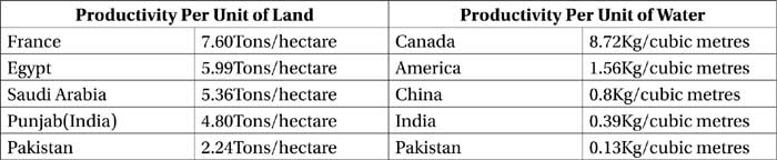
Table 4: Comparison of Productivity per Unit of Land and Water
The issue of water is emotive, touching people across Pakistan in a much more fundamental way than the demand for Kashmiri self-determination. Per capita water availability has fallen precipitously over the past few decades, due to rising population and poor water management and is expected to fall below 1,000 cubic metres by 2025 — the international marker for water scarcity. In most years, the Indus barely makes it beyond the Kotri barrage in Sindh, leading to ingress of sea water, increase in soil salinity and destruction of agriculture in deltaic districts like Thatta and Badin. The current situation with regard to the degradation of the agricultural resource base is:
38 percent of Pakistan’s irrigated lands are waterlogged and 14 percent is saline.
Only 45 percent of cultivable land is under cultivation at a given time.
Salt accumulation has invaded the Indus basin and there is saline water intrusion into mined aquifers. Sea water intrusion has reached 225 kilometres inland.
Pakistan’s obsession with water must be understood in the context of the tremendous importance of the rivers of the Indus Basin for the survival of Pakistan and parts of Northern India. Though Pakistan’s water woes predate recent hydroelectric projects like Baglihar in Jammu and Kashmir, jihadi organisations have started blaming India for the growing shortage of water. Apart from inflaming public opinion against India, this propaganda helps to blunt the resentment Sindh and Balochistan have traditionally had — as the lowest riparian in the Indus river basin — against Punjab for drawing more than its fair share of the water flowing through the provinces. The campaign also deflects criticism of Pakistan’s own gross neglect of its water and sanitation sector infrastructure over the past few decades.
Pakistan’s obsession with water must be understood in the context of the tremendous importance of the rivers of the Indus Basin for the survival of Pakistan and parts of Northern India.
At the same time, the fact that river flows from India to Pakistan have slowly declined is borne out by data on both sides. Above Marala on the Chenab, for example, the average monthly flows for September have nearly halved between 1999 and 2009. India says this is because of reduced rainfall and snowmelt. Pakistan links reductions in flows to hydroelectric projects on the Indian side. Pakistani officials from time to time accuse India of violating the IWT. India denies this and there is, in any case, a system of international mediation built into the IWT for binding international arbitration if the two countries cannot resolve a water-related dispute. Pakistan invoked this mechanism for Baglihar in 2005, though the arbitrator ruled in favour of the project subject to certain modifications. An earlier dispute over the Salal project was resolved in the 1970s. Today, nothing prevents Pakistan from referring any or all of the projects India proposes to build on the Chenab and Jhelum rivers for arbitration. Mercifully, there have been no accusations of ‘water theft’ by India.
Though the treaty has a mechanism to ensure compliance with the stipulated partitioning of rivers, a major weakness from Pakistan’s standpoint is that it does not compel or require India to do anything on its side for the optimum development of what is, after all, an integrated water system. Inflows to Pakistan depend not just on rainfall and snowmelt in India and China (the uppermost eastern riparian) but also on the health of tributaries, streams, nullahs and aquifers as well as groundwater, soil and forest management practices. This is a classic problem. Costs incurred by the upper riparian on responsible watershed management produce disproportionate benefits for the lower riparian, so they are not incurred.
The IWT anticipated the importance of cooperation with Article VII stating that both parties “recognise that they have a common interest in the optimum development of the rivers, and to that extent, they declare their intention to cooperate, by mutual agreement, to the fullest extent”. So far, little has been done by either side to develop this mandate.
Costs incurred by the upper riparian on responsible watershed management produce disproportionate benefits for the lower riparian, so they are not incurred.
Today, both countries are facing the same problems with irrigated agriculture, i.e. waterlogging and soil salinity. Over the past 20 years, groundwater use has been a major factor in increasing agricultural production. Tube-wells not only supply additional water but have provided flexibility to match surface water supplies with crop water requirements. However, because of uncontrolled and rapid development of groundwater (six percent annual growth), there is a danger of excessive lowering of water tables and intrusion of saline water into freshwater aquifers. Within the IBIS, total water availability at the farm gate has significantly increased in the last 15 years, and changed slightly in its composition, with a higher use of groundwater extracted by tube-wells. In 1975, surface water represented 70 percent of the total water available, groundwater provided through private tube-wells 22.5 percent and through public tube-wells 7.5 percent. In 1990, the figures were 63 percent, 27 percent and 10 percent respectively. It has been estimated that the average water losses from canal head to outlet are 25 percent, and from outlet to farm gate are 15 percent in Pakistan.
The increasing diversion of river flows has significantly changed the hydrological balance of the irrigated areas in the past century. Initially, irrigation systems were developed without any provision for drainage. Seepage from irrigation canals and watercourses, and the deep percolation of this water have gradually raised the groundwater table, causing water-logging and salinity. It is estimated that about 2.39 million hectares had water tables within 1.5 metres of the surface level in June 1989 (which resulted in 4.92 million hectares in October 1989, just after the monsoon season). Such areas are “disaster areas” and need high priority for drainage. According to the Soil Survey of Pakistan (1985-1990), 1.78 million hectares are considered as severely saline and 0.18 million hectares as very severely saline, but the survey does not indicate which part is due to irrigation.
There is also a dispute between the provinces of Pakistan as regards sharing of the Indus waters. An accord was reached in 1991 based on the availability of 114.35 MAF per year, with a 3 MAF estimate for un-gauged canals. Though availability varies from year to year it is normally less than 117.35 MAF. The division among the provinces is at Table 5. (There is a demand of Sindh for a 10 MAF provision for downstream flow is, but this is not yet finalized).

igure 4: Province-wise Irrigated Area
While framing the IWT, the irrigable area of India and Pakistan was assessed at 26 million acres and 39 million acres respectively, while the waters available to them are 32.8 MAF and 135.6 MAF respectively. This means that only about 1.26 feet of water is available to India for its agriculture on eastern rivers, while about 3.5 feet of water is available to Pakistan for its agriculture. Within Pakistan itself, there is a debate about the need for the government to improve its management of water.
 Table 5: Province-wise Allocation of Water in the 1961 Accord
The Province-wise irrigated area is given diagrammatically at Figure 4.
Pakistan has a large surplus of unused water. Its documents show about 30 MAF as “available surplus” with a very high ‘escapage’ to the sea. Pakistan’s irrigation efficiency is also understood to be low, at an estimated 40 percent. Virtually all of the municipal and industrial wastewater is returned to the rivers, nullahs and streams untreated, which results in deterioration of water quality. Canal capacities are also not sufficient to provide the share of each province according to their allocation. The inflow of water for irrigation has declined from 140 MAF in the 1980s to an average of 100 MAF in 2005. It is feared that it will decline further as the flows in the three rivers are reducing at the rate of 6.6 per cent per year. While Pakistan’s irrigation network is vast, it is managed in an extremely inefficient manner.
…Jammu & Kashmir is a source of Pakistan’s water and food security. It is a real estate dispute for strategic resources. To the outside world, it is projected that Pakistan is supporting a struggle for self-determination for the people of Kashmir.
Pakistan’s water woes are compounded by silting at the Tarbela and Mangla dams, with an internal official assessment admitting that it has lost 32 percent of its storage capacity due to the problem.
The Indus River System carries about 43,500 hectare metres of silt every year. About 40 percent of the silt settles before reaching the Indus mouth. In particular, the Tarbela dam is losing storage capacity of 100,000 cusecs each year. At this rate it will be difficult to support cotton sowing and wheat maturity, even though the designed life span of this dam is until 2030.
The ground water resources are also fast depleting. As compared to 3.34 MAF in 1959, ground water pumping reached 55 MAF by 2009. As a result of over-pumping, about 70 percent of Pakistan’s half-a-million tube-wells produce hard or brackish water. If the network of canals and tube-wells continue to provide gradually reducing quantities of fresh water, Pakistan will face a serious crisis in its agricultural output. Already the country faces a shortfall in food-grain availability of about 4 million tonne per year and this will treble in a decade. Besides, production of cotton, which is the most important source of foreign exchange revenue, will be severely affected. Most important, the unity of the country will be undermined.
The impact of the declining supply of water is the worst on Sindh and Balochistan. Sindh, almost completely depends on canal irrigation, as groundwater sources have become unfit for use. Salinity and waterlogging has affected 88.8 percent of agricultural land. They bear the brunt of the large and inefficient irrigation network. The diversion of water upstream has resulted in the decline of water downstream. Sea intrusion has already destroyed 1.5 million acres of farmland in the two coastal districts of Badin and Thatta resulting in the demise of three commercial towns Ghorabhari, Shah Bandar and Ketti Bandar and displacement of 250,000 people. The cumulative economic loss is close to 2 percent of GDP.
…as Pakistan turns off the terrorism tap, India can offer to turn on the water.
Punjab and Sindh are at loggerheads over deciding a formula to distribute shortages in water flows. Sindh demands the implementation of the Water Accord of 1991, whereas Punjab insists on a formula worked out in 1994. The politicians launch a war of words every year at the end of winter regarding water. This altercation reaches its peak at the time of kharif sowing in May-June and then subsides with the onset of rains. This is because the water flows in the Chenab and Indus are relatively low during early kharif sowing (April-June), while that in the Jhelum is relatively high during the same period. With Punjab’s exclusive rights on the Mangla, it can draw sufficient waters. Sindh is left to the mercy of the rain gods.
Sindh is also opposing the construction of the Thal canal which is designed to provide an additional 1.9 MAF water to Punjab from the Tarbela reservoir. The project covers four districts of Punjab Bhakker, Layyah, Khushab and Jhang. (Interestingly, this is the area where there is a concentration of jihadis and the private landholdings of senior military officials. The Board of Revenue of Punjab revealed in June 2003 that 112 military officers including General Pervez Musharraf had been allotted land in Cholistan at nominal rates. The Thal canal is required to build small dams to irrigate Cholistan for their benefit). Ownership of land remains a proxy for water rights, especially in agricultural areas. This excludes landless farmers. Moreover, ‘rights’ to water are ill-defined in Pakistan.
In order to prevent conflict between Punjab and Sindh, and a possible secession of Sindh and Balochistan, Pakistan needs physical control over the Chenab catchment region in Jammu & Kashmir in India. It needs to build dams, to store, divert and regulate water flows. It also needs additional fertile land. Thus, Jammu & Kashmir is a source of Pakistan’s water and food security. It is a real estate dispute for strategic resources. To the outside world, it is projected that Pakistan is supporting a struggle for self-determination for the people of Kashmir. To the leaders of Pakistan, Syed Salahuddin, chairman of the United Jihad Council, often assures that the Kashmir youth are fighting a war to help Pakistan secure its lifeline.
Many of the disputes that seem to be driven by fears of water scarcity are actually a reflection of another kind of scarcity: electricity.
Pakistan is on the brink of water disaster. Its availability has decreased to 1,200 cubic metres per person from 5,000 cubic metres in 1947 and is predicted to plunge further. Persistent drought has left the country with 30 percent less irrigation water than average for the spring crop. The Sindh government has accused their Punjabi counterparts of diverting more water than they are allocated. But officials in Punjab argue that the water deficits come from high system losses. Pakistan doesn’t have a national monitoring system for canal water flow, making verification of the claims more difficult.
Many of the disputes that seem to be driven by fears of water scarcity are actually a reflection of another kind of scarcity: electricity. Pakistan opposes the Indian Kishenganga hydel project on the Jhelum because it will interfere with its proposed Neelum-Jhelum power plant.
Conclusion
Pakistan faces a water crisis and any attempt to blame India is a non sequitur. Pakistani unease about Indian projects on the western rivers, despite the many stringent safeguards provided by the IWT, suggests that it requests a re-look at the provisions of the Treaty. A military view is that India will be able to use water as a weapon of war. The only way to stop the world from labelling Pakistan as a citadel of terrorism is for it to distance itself from jihadi organisations that are considered as an asset by its national security managers. These groups are actually a great diplomatic liability to the country by laying the bogey of blame for the water troubles at India’s doorstep.
India is using less than its irrigation entitlement in Jammu and Kashmir and has created no water storage on the three western rivers. All the Indian projects are run-of-the-river and, given the restrictive provisions of the IWT, there is hardly any scope either for the retention of waters to the detriment of the lower riparian or for flooding the lower riparian. In actual fact Pakistan is getting more water than its entitlement because of India’s inability to use the water it is entitled to.
Pakistan only has the capacity to hold a 30-day reserve storage of water as a buffer against drought.
Pakistan needs to rebuild and overhaul the administration of the world’s largest contiguous irrigation network. For decades, Islamabad has spent far too little on basic maintenance, drainage and distribution canals, new water storage and hydropower plants. The result is an agricultural crisis of wasted water, inefficient production and incipient crop shortfalls. There have been repeated riots over lack of water and electricity in Karachi, and across the country people suffer from contaminated drinking water, poor sanitation and pollution.
The future looks grim. Pakistan’s population is expected to rise to 220 million over the next decade, up from around 170 million today. Flows of the Indus are expected to decrease as global warming causes the Himalayan glaciers to retreat, while monsoons will get more intense. While glacial melting will eventually reduce river flow in the low season, an increase in temperature in some areas will cause heavy precipitation concentrated for a few days during July-September. This will increase the risk of flooding. In the next 20 years, the Himalayan sub-region will face the depletion of almost 275 billion cubic meters (BCM) of annual renewable water. Pakistan only has the capacity to hold a 30-day reserve storage of water as a buffer against drought. It appears that water — and not terrorism — tops the Pakistani agenda today. Perhaps India needs to take a strategic view and suggest that for Indian cooperation on water Pakistan needs to abandon the agenda of terrorism it has nurtured all these years as an instrument of policy against India, i.e. as Pakistan turns off the terrorism tap, India can offer to turn on the water. However, the problem is not that simple as it revolves around trust.
India needs to take a strategic view and suggest that for Indian cooperation on water Pakistan needs to abandon the agenda of terrorism it has nurtured all these years as an instrument of policy against India
The Indus waters issue is being needlessly politicized with specious arguments. India, meanwhile, is straining to cope with its own severe electricity shortages and is building a series of hydropower dams on Indus tributaries in Jammu and Kashmir. While technically permissible under the treaty provided the overall volumes flowing downstream are not diminished, untimely dam-filling by India during planting season could destroy Pakistan’s harvest. Pakistan, downriver and militarily weaker than India, understandably regards the dams’ cumulative one-month storage capacity as a potentially lethal new water weapon in India’s arsenal.
Pakistan needs to start the Diamer-Bhasha dam, an agricultural and hydroelectric project on the Indus that’s been on the drawing board for decades. The project is likely to cost more than $12 billion but has languished for want of financing. It has also has run afoul of the developed world’s disfavour of giant dams. It can add desperately needed water storage and hydroelectricity as Pakistan is tapping just 12 percent of its hydropower potential.
The IWT has stood the test of time in resolving differences. The Commission has met over a 100 times since the treaty was signed half a century ago to exchange information and iron out irritants, which means that the mechanism has been working well. Pakistan needs to build storage capacities because climate change is impacting the quantum of water available. The globally growing number of crises and disasters, and the more and more intricate, complex and multi faceted nature of risks require an innovative, integrated and problem oriented approach to risk and disaster knowledge and management. Laying the blame for problems on outsiders leaves little or no incentive to fix them. Pakistan cannot keep looking for causes and solutions outside her borders. Since quantitative issues are controversial, a beginning can be made with data sharing on water quality monitoring. Cooperation and not conflict is the sane way forward. Cooperation on the water issue should be looked upon as a means to a peaceful co-existence. Joint water management offers the scope for people-to-people and/or expert-to-expert connections, thus creating a channel for peaceful dialogue irrespective of political and military developments.
No comments:
Post a Comment